
The Ring of Bookan

By Sigurd Towrie
(updated May 18, 2026)

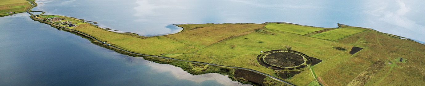
The Ring of Bookan is a huge, ditched enclosure sitting on a ridge a mile to the north-west of the Brodgar stone circle.
The massive earthwork comprises a flat-bottomed ditch – circa 13.5 metres wide and surviving to a depth of up to two metres – surrounding an oval, raised platform measuring about 45 metres by 40 metres.
Like Maeshowe, about two-and-a-half miles to the south-east, there is no causeway across Bookan’s huge, encircling ditch, suggesting access was not intended.
It sits in a landscape featuring three other, well-known, ditched monuments. [1] and for well over a century the Bookan “ring” has been the subject of debate. In particular, what was it?

Its position at the start (or end) of a line of stone circles naturally led to the assumption that it was another – albeit one that seemed to have lost its megaliths.
The absence of standing stones is perhaps the reason that Bookan was largely ignored by antiquarians.
“[T]he Ring of Bûkan [1b] … seems to have escaped the notice of all those who had described the antiquities of Stenness,” wrote Lieutenant Thomas, who surveyed the monuments around the Ness of Brodgar in 1848. [2]
He added: “It may indeed be easily passed without attracting attention.”

The scale of the ditch led Thomas to conclude that the Ring of Bookan “was of the same genus” as the Ring of Brodgar. Where it clearly differed, aside from the lack of standing stones, was that the interior of Bookan still contained visible archaeology:

While Thomas’ speculation about cromlechs [3] was way off the mark, his mention of “compartments” is interesting. Local tradition has it that a “chamber” was still accessible in the early 1800s, but no details survive. When Nick Card lived beside the ring, he was told by an older gentleman, whose family had been in the area for generations, that the Bookan “chamber” was a regular haunt of his forebears (in their younger years) until safety fears saw it blocked with stone.
The Sandwick historian and folklorist George Marwick is of little help when it comes to Bookan.
Writing around 1892, he simply declared the earthwork seemed “to have been an affair of nearly the same kind as the circles [Stones of Stenness and Ring of Brodgar] of the lower grounds”. [4]
He does, however, introduce an alternate name for the site – “the Rim of Bookan”. Rim, or rimman, Marwick explained was a word “still used in Orkney, and means the horizon.” [4]
This is correct, but the dialect word rim had an alternate meaning and was used to refer to rocky ground, particularly rocky areas protruding above the sea (from Old Norse rimi, an elevated strip of land). One cannot help but wonder if this referred to the stone features protruding from the centre of the ring.
Unfortunately, Marwick recounts nothing else useful about the ring, venturing instead into nonsensical speculation about the Bookan placename. [5]
While it is tempting to consider Marwick’s ramblings about hidden recesses in his Bookan accounts as relating to a lost chamber – and perhaps the recesses since encountered in the architecture of the Ness of Brodgar structures – this is probably pushing it too far.

Uncertainty about the nature of the Bookan ring is primarily due to the fact it has never been excavated. Even in the 19th century, the antiquarians were clearly more interested in opening the mounds lying in its vicinity.

That said, the Orcadian antiquary George Petrie, known for excavating and recording numerous Orkney sites, did document the Ring of Bookan. Whether he carried out any sort of excavation or simply surveyed the site is not clear.
In his unpublished notes, he wrote:
The problem interpreting the surface remains within the “ring” has been due to the assumption that the archaeology represented a single-phase monument.
Excavation at the Ness of Brodgar complex encountered multiple episodes of rebuilding and modification and the situation at Bookan may have been the same, with the site remodelled or partially dismantled in antiquity – perhaps more than once.
By the 1960s, the favoured interpretation was that Bookan represented the denuded remains of a Maeshowe-type chambered cairn [6] – an idea largely abandoned by the 1980s.
Graham Ritchie, who excavated at the Stones of Stenness in 1973/74 [7], suggested the Bookan ring was a “henge monument with a series of internal stone settings or a cairn.” [8]

This was based on parallels noted between the ditches at Bookan and the Stones of Stenness.
Although the Bookan ditch is wider, it is similar in depth and enclosed a similar area.
This is interesting when we consider the results of a ten-year UHI Archaeology Institute geophysics programme that surveyed over 285 hectares of the Heart of Neolithic Orkney World Heritage Site.
Although appearing oval on the surface, the geophysical surveys actually revealed the Bookan monument to be sub-rectangular – the inner area enclosed by a rectangular ditch with rounded corners. This discovery was hinted at in Petrie’s 19th century plan of the site.
Overall, the project revealed a site that appears very similar to the large, monumental Neolithic structures excavated to its south-east [9] – Structure Eight at Barnhouse and Structure Ten at the Ness of Brodgar, both of which date from c.2900BC.
In addition, it confirmed the presence of another large Neolithic settlement complex – complete with monumental structures – to the north of the Ring of Bookan. The location of the ring in relation to this settlement, is notable, perhaps paralleling the relationship between the Barnhouse settlement and the Stones of Stenness. [10]

Following the excavation of the Barnhouse settlement in the 1980s, the spatial similarity between Structure Eight and the Stones of Stenness prompted Professor Colin Richards to suggest the stone circle stood on the site of an earlier “house”.
Although the interior of the Stones of Stenness was partially investigated during the excavations of 1973-74, the excavators concluded it “could not be fully interpreted”.
A two-metre-square hearth was revealed at the centre of the stone circle, north of which was a rectilinear feature interpreted as a timber structure, associated with two socket holes and linked to the hearth by a flagstone path. [7]

Based on the central hearth, Aubrey Burl suggested in 2000 that the stone circle “may have been set up on the site of an earlier Skara Brae type of house”.
Prof Richards, however, noted that the features in the interior of the Stone of Stenness closely resembled architectural elements of Barnhouse’s Structure Eight.
He felt the evidence that a “big house” once stood on site was compelling and that its remains had been covered by a thick clay platform [10] – a practice known from both Barnhouse and Maeshowe.
This structure, he suggested, was taken out of use, its walls demolished and the exposed hearth enlarged. Removing the walls meant an alternative method of containing the interior was required, so the site was enclosed by towering megaliths.
Finally, an “extreme form of physical boundary” was created in the form of a four-metre-wide, 2.3-metre-deep ditch.
Are we looking at something similar at Bookan?
A sequence of large, monumental structures associated with a nearby settlement that were allowed to decay, or deliberately dismantled, before the site was sealed off by the addition of an enclosing ditch with no access causeway?
Only excavation can provide the answers.

Notes
- [1] Two stone circles – the Ring of Brodgar and the Stones of Stenness – and a chambered cairn, Maeshowe.
- [1b] The spellings varied then and still do. Petrie refers to it as “Buccan” in 1867. Today the area around Bookan has various versions of the same placename, e.g. Buckan, Bockan.
- [2] Thomas, F.W.L. (1851) Account of some of the Celtic Antiquities of Orkney, including the Stones of Stenness, Tumuli, Picts-houses, &c., with Plans, by FWL Thomas, RN, Corr. Mem. SA Scot., Lieutenant Commanding HM Surveying Vessel Woodlark. Archaeologia, 34(1).
- [3] Dolmens. Structure consisting of a large, flat, unhewn stone resting horizontally upon three or more uprights.
- [4] Marwick, G. (1892) The Standing Stones of Stenness – Traces of the Ancient Road from the Quarries. In Muir, T. and Irvine, J. (eds) 2014. George Marwick: Yesnaby’s Master Storyteller. The Orcadian: Kirkwall.
- [5] Among the variants used by Marwick are: Bocan, Bukin, Bookin, Bokin, Bukan and Bookan.
- [6] Henshall, A. (1963) The Chambered Tombs of Scotland. Volume One. Edinburgh University Press, Edinburgh.
- [7] Ritchie, J.N.G. (1975) The Stones of Stenness, Orkney. In Proceedings of the Society of Antiquaries of Scotland (Vol. 107, pp. 1-60).
- [8] Ritchie, J.N.G. (1985) Ritual monuments. In Renfrew, C. (ed) The Prehistory of Orkney. Edinburgh University Press. pp.118-30.
- [9] Brend, A., Card, N., Downes, J., Edmonds, M. and Moore, J. (2020) Landscapes Revealed: Geophysical Survey in the Heart of Neolithic Orkney World Heritage Area 2002-2011. Oxbow Books, Oxford.
- [10] Richards, C. (2013) Wrapping the Hearth. In Richards, C. (ed) Building the Great Stone Circles of the North. Windgather Press, Oxford. Pp. 64–89.


