
Wasbister settlement and disc barrow

By Sigurd Towrie
In the Bronze Age, the people of Orkney gravitated towards the sites of already ancient monuments to bury their dead. As a result, clusters of barrow mounds can often be found around chambered cairns and other Neolithic monuments.
These sites “were no longer historic; they were a part of the mythic landscape” and, as such, probably chosen as “burial grounds for lineages who were still looking to the past.” [1]
“[P]eople gathered to honour their dead in company, funerals drawing a certain gravity from what was, by then, a site of historic and probably legendary significance.” [1]
As Prof Mark Edmonds put it:

From the large number of funerary barrows clustered around the Ring of Brodgar, there is no doubt that the stone circle remained an important focal point in the Bronze Age, by which time the surrounding landscape had taken on “a more tangible association with the dead.” [2]
Although it was clearly considered desirable to be buried in the vicinity of the ring, another concentration of barrows lies around the high ground to the north-west of the Ness.
There, although many have now been lost to the plough, we have a concentration of burial mounds to west of the Ring of Bookan, around Skaefrue and on a ridge at Wasbister, overlooking the flat, low ground running to the Brodgar ring.
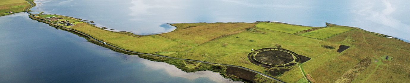
Directly beneath the Wasbister barrow cemetery, however, is a site that few visitors to the Ness will know about – a substantial area of Bronze Age activity that covers an area of approximately four hectares. [2]
Only a few elements remain clearly visible above ground, particularly in aerial photographs, but in 2005, geophysical surveys revealed an “extensive spread of magnetic enhancement” and a large complex of structures, enclosures and field systems running across the width of the peninsula. [2]

This unexcavated settlement sits on low ground, about 400 metres to the south-east of the Bookan chambered cairn.
George Marwick’s declaration that “…there has been a great deal of buildings on a large scale, though now it is all buried” suggests more was still visible in the final decades of the nineteenth century. [3]
Among the features still obvious today is a pair of low, adjacent mounds.
Described in 1851 as “two obscure circles, which appear to be of the nature of cromlechs”, it was declared “very probable that these were graves from which the covering and other stones have been carried away.” [4]
This interpretation changed little over the years, although in the early 20th century it was stated they “resemble hut circles…” [5] but, because of their size, the idea they might represent buildings went no further.
In 2005, however, the geophysics results were clear.
The figure-of-eight feature was a Bronze Age double-house – two sub-circular buildings measuring c.19 metres and 12 metres in diameter, with facing entrances.
The surveys indicated a hearth in the centre of the larger building, which had a south-easterly facing entrance. The geophysical response from the paired structures was similar to that noted at probable Bronze Age buildings at the Bay of Skaill, which were “of comparable scale, orientation and spatial arrangement.” [1]


Surrounding the double-house were features that probably relate to field boundaries, while around 70 metres to the north-east was another possible Bronze Age dwelling.
Oval-shaped and measuring c.16 metres by 12 metres, with its long axis aligned north-west to south-east, this structure is similar to the larger of the double-house pair but may have had a more elaborate entrance on its western side, facing a second, smaller, building. [1]
Three other possible structures lie nearby. Measuring between eight and ten metres in length, the geophysics results gave no clear indication of interior features. [1]
Although the surveyors felt these could be smaller Bronze Age buildings related to the double-house, their size and appearance was more reminiscent of Neolithic architecture encountered at the Stonehall settlement in Firth, Orkney, just under four miles directly to the east.
To further complicate matters, they were also similar to the cellular Iron Age architecture from Buckquoy, in Birsay. [1]
Without excavation, all that can be said about these three structures is that they represent occupation – but that could be anywhere from 3300BC to AD700.
The burial mounds above the Wasbister settlement fits a pattern noted throughout Orkney. In the Bronze Age, barrows were placed on false summits and ridges overlooking settlement sites [2] – suggesting they were meant to stand out when viewed from the adjacent low ground.

A second large, visible feature is a substantial Bronze Age disc barrow, lying around 100 metres to the south of the Wasbister double-house.
Positioned immediately to the north of the Dyke of Sean, and close to the shore of the Stenness loch, the monument has a diameter of around 28 metres and is made up of a concentric circular ditch and bank, surrounding a central mound with a diameter of 15 metres and which survives to approximately 80 centimetres in height.
During his 1848 survey work on the Ness, Lt Frederick Thomas noted that the “small circle” was “of the same form as that beyond Brogar, but without upright stones”. [4]

Thomas’ map of the area shows the “road to [the parishes of] Sandwick and Birsa” running past the barrow and continuing along the west side of the isthmus. It was visible in the geophysics data as a linear feature, running north-west/south-east for around 150 metres to the west of the Bronze Age settlement, before continuing onwards to the Ring of Bookan and beyond. [4]
It will require excavation to confirm whether the barrow and settlement were contemporary, but the funerary monument’s position on its outskirts – a liminal area – suggests they may be. From the geophysics data, the barrow occupies a quiet spot outside the extremely busy area of magnetic enhancement. [2]
The surveys of the barrow’s central mound also revealed features that probably represent cremation burials or funeral pyres [2]. They also showed a low bank/ridge running east-north-east by west-south-west from the eastern end of the barrow for around 35 metres.
This feature then turns sharply and runs c.22 metres north-south. It is, however, not clear what this feature represents or whether it post-dates the construction of the barrow. [2]
Notes
- [1] Edmonds, M. (2019) Orcadia: Land, Sea and Stone in Neolithic Orkney. Head of Zeus Ltd.
- [2] Brend, A., Card, N., Downes, J., Edmonds, M. and Moore, J. (2020) Landscapes Revealed: Geophysical Survey in the Heart of Neolithic Orkney World Heritage Area 2002-2011. Oxbow Books, Oxford.
- [3] Marwick, G. (1892) Howastedgarth, The Standing Stones, Stennis. In Muir, T. and Irvine, J. (eds) 2014. George Marwick: Yesnaby’s Master Storyteller. The Orcadian: Kirkwall.
- [4] Thomas, F.W.L. (1851) Account of some of the Celtic Antiquities of Orkney, including the Stones of Stenness, Tumuli, Picts-houses, &c., with Plans, by FWL Thomas, RN, Corr. Mem. SA Scot., Lieutenant Commanding HM Surveying Vessel Woodlark. Archaeologia, 34(1).
- [5] Canmore: https://canmore.org.uk/site/1705/bookan


