


Bay of Firth Neolithic Trail – click on any location for further details.

The landscape around the Bay of Firth, in roughly the centre of the Orkney Mainland, is rich with archaeological remains. Although most are not visible above ground, the area features three Neolithic chambered cairns, in an east-west line, within three miles of each other.
Of these, only two are accessible to the public – the passage graves on Cuween Hill and Wideford Hill.
For the purpose of this trail, we’ll assume a starting point in the village of Finstown, which lies on the main road between Kirkwall and Stromness.
To those without transport, Finstown is served regularly by public transport. Click here for bus timetables.
For anyone planning on visiting the two chambered cairns on foot or by bicycle, please be aware it will require travelling on a busy road, so please take care.
Cuween Hill chambered cairn

The Cuween cairn lies to the south-east of Finstown, so head east along the main A965 road until you reach the junction with the Old Finstown Road. Turn right and follow the road, for approximately half a mile, until you reach a signposted track that leads to the site’s car parking area.
From there it is a case of negotiating a steep, uneven path to the monument, which is fenced off and accessed by a stile. Like all chambered cairns, the entrance is low and narrow and requires the visitor to crawl the length of the passage.
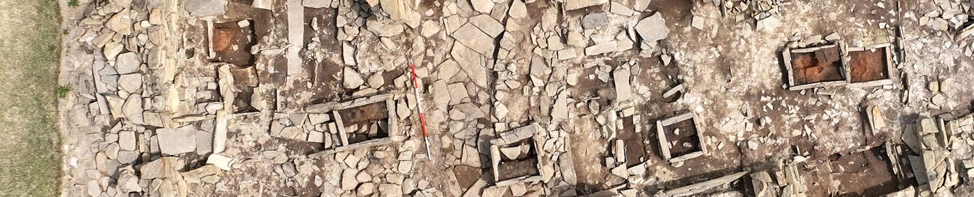
From 1994 until 2000, excavation in the shadow of the Cuween cairn revealed an extensive Neolithic settlement. Founded in the fourth millennium cal BC, occupation at Stonehall ran into the third millennium cal BC, following the gradual pattern of conglomeration and nucleation noted at other Neolithic settlement sites in Orkney.
From Cuween look to the right, along the base of the ridge of high ground running behind the cairn, to see the site of the Stonehall settlement – probably the home of the cairn’s builders.
From the cairn’s entrance, the Wideford Hill passage grave is visible directly opposite, on the upper slopes of the hill.
Wideford Hill chambered cairn

Returning to the Old Finstown Road from Cuween, follow it for approximately 3.5 miles until a sign for the Wideford Hill cairn indicates to turn left. Follow this road up the hill until you reach to a signposted car parking space.
From here follow the c800-metre track (0.5 miles) along the flank of the hill to reach the cairn. Again, this path is over uneven ground so not suitable for wheelchairs.
Access to the interior is now via a hatch and ladder in the cairn roof.
Neolithic settlements

Throughout the area are the excavated sites of Neolithic settlements – Stonehall, Smerquoy, Wideford Hill and Crossiecrown. Nothing of these is visible above ground today but their presence highlights how busy the area around the Bay of Firth was in the Neolithic.
We have dealt with Stonehall above, but directly beneath the Wideford passage grave, on low ground at the foot of the hill, fieldwork in 2002-2003 confirmed the existence of another substantial Neolithic settlement. Initially made up of timber structures, the excavated section of the settlement was in use from around 3500-2900BC.
In 2003, another Early Neolithic settlement, Smerquoy, was confirmed at the south-western base of Wideford Hill. Radiocarbon dates from the Smerquoy settlement suggests timber buildings were prevalent from around 3600BC until stone-built houses became the norm c3300BC.
To the north of Wideford Hill, closer to the shore, the Crossiecrown settlement site was excavated between 1999 and 2000, the focus being a low mound around 40 metres in diameter. The project revealed a multi-phase site with occupation running from the fourth to the second millennium BC.
More recently, another suspected Neolithic settlement site was found at the base of Wideford Hill’s eastern slopes.
Underwater archaeology

Although there is no shortage of archaeology still underground, an intriguing element of the Bay of Firth landscape is that it is highly possible structural remains survive under water.
Stories about mysterious underwater objects had been commonplace for years and between 2005 and 2009, the Rising Tide project confirmed the existence of a number of possible prehistoric features on the sea bed.
The reason for this? In the Neolithic what is now the shallow Bay of Firth was dry land.
Rising sea levels only reached their present position around 2000BC – at least 1,000 years after the construction of the Wideford and Cuween passage graves.
For full details, click here.


