
The Stones of Stenness

By Sigurd Towrie
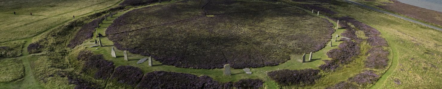
The smaller of the two stone circles in the Heart of Neolithic Orkney World Heritage site is now commonly known as the Stones of Stenness [1]. It stands on the headland opposite the south-eastern tip of the Ness of Brodgar peninsula, the two now joined by the Brig o’ Brodgar.

Like the Ring of Brodgar, a mile to the north-west, the Stones of Stenness has been designated a henge monument. [2]
Surrounded by a flat-bottomed, rock-cut ditch, four metres wide and 2.3 metres deep [3], the circular enclosure has an approximate diameter of 44 metres and a single, c. eight-metre-wide entrance, to the north. There may, however, have been a second entrance to the south. [14]
But although the Stones of Stenness covers a much smaller area than the Ring of Brodgar, three of its four surviving megaliths are larger, standing at a maximum height of six metres.

Dates and excavation
Long said to date to around 3100BC, the Stones of Stenness were hailed one of the earliest stone circles in Britain and Ireland. More recently, however, a reanalysis of Orcadian radiocarbon dates suggested a later date – around 2900BC. [2b]
These dates, however, derive from animal remains from the bottom of the ditch, meaning we are once again left pondering which came first – the stones or the ditch. If the ditch was a later addition – dug to enclose the stone circle and its interior – then the erection of the megaliths could be much, much earlier.

Regardless, what the dates do show is that at the same time as the nearby Ness of Brodgar complex and Barnhouse settlement were in use, a stone circle had been raised – or was under construction – and formed an imposing part of the landscape.
The ditch was partially excavated in 1973/74, producing Neolithic pottery sherds and the remains of cattle, sheep and dogs (or, due to the size, wolves were suggested) [3]. These could either indicate that “offerings” were placed or that the ditch was used to dump, or deposit, material relating to activities inside the ring.
At the entrance causeway, a human finger bone and a fragment of femur (possibly also human) were among the excavated deposits. [3]
During its excavation, the ditch kept filling with water. This, together with archaeobotanical evidence of aquatic plants [3] suggested it held, at least some of the time, water. This prompted the suggestion that a water-filled ditch was a deliberate element of the design. [4]


Ditch, bank and wall?
The Stones of Stenness is regularly described as a classic example of a henge monument. Following typology, a henge requires an external ditch and bank. But here, while the existence of the ditch is not in doubt, the presence of an external bank remains the subject of debate.
In the 1770s, the Rev George Barry stated the monument was:
Although he did not detail the “mound of earth”, Barry described the Stones of Stenness as a “semi-circle” – an element common in numerous early accounts of the monument. [5]

A 1772 watercolour of the Stones of Stenness (above) seems to corroborate Barry’s 18th century observation, and the later 19th century accounts, showing a semi-circular ridge to the south-west of the standing stones. [7]
The bank also appears in the map (below) of the Ness of Brodgar produced around the same time. [8]

An 1837 plan, based on measurements by Dryden and Petrie, highlighted a “very slight” bank to the south-west, while, in 1848, a raised “circumscribing ring” was noted outside the ditch. This only survived for “one third of the circumference”. [6]
On his plan of the stone circle (below), Lieutenant F.W.L. Thomas suggested this “raised bank” only survived in the south-western quadrant. [6]

If Cleveley’s 1772 illustration is a reasonable record of the site, it suggests that much of the surviving bank must have been obliterated over the following 76 years. By 1848, the bank was said to be the same height as the low, domed mound within the monument. [6]

Incidentally, this ridge was behind the notion that the monument was originally semi-circular – something dismissed by Lieutenant Thomas. The antiquarian “Temple of the Moon“ label undoubtedly owed much to the crescent-moon-shape of the surviving earthwork.
The 1973/74 excavation saw two trenches opened over the documented bank, concluding it was “completely denuded” and “must have been broken down and scattered by years of ploughing” [3]. All the archaeologists encountered was a thin band of clayey soil and silt that, despite the “tenuous nature” of the surviving evidence, was interpreted as the sole remains of a former outer bank. [3]

To Professor Colin Richards, the idea that an external bank – composed of an estimate 1,300 tonnes of material from the ditch – could completely disappear confounds belief. Instead, he pondered whether the notion there was a bank owed more to the fact that, typologically, a henge should have one rather than the archaeological evidence. [9]
He proposed that the clay band encountered in the 1970s was actually the foundation spread for an enclosure wall [9] – much like the one found around Maeshowe in the early 1990s. [10]
It is an intriguing possibility, given what we now know about the enclosing walls around the Ness of Brodgar’s Structure Ten and Barnhouse’s Structure Eight, both of which also date from around 2900BC. – not to mention the Ness’ two massive boundary walls and the isthmus-spanning Dyke o’ Sean to the north-west of the Ring of Brodgar.
So. Wall or bank? The archaeological evidence for either is inconclusive and the bank visible is the result of consolidation work carried out in the 1980s.
An incomplete stone circle
The earliest detailed account of the Stones of Stenness confirms that only four megaliths were still standing in 1760, with a fifth lying prone. This situation that remained unchanged until December 1814, when a tenant farmer set out to rid his land of the megaliths that were apparently making his life difficult.
After destroying the Odin Stone, the miscreant turned his attention to the Stones of Stenness, toppling one megalith and destroying another before he was stopped. We return to this unfortunate episode in the second part of this article.

Based on the angle and distance between known stones and stumps, it was long believed that the Stones of Stenness was a circular monument containing 12 equally spaced megaliths around its circumference.
Unfortunately, most visitors are still told that today!
Excavation, however, confirmed the stone circle was laid out in an ellipse and that only ten stones – eleven at the most – were ever raised. [3]
While the missing megaliths were represented by socket holes, stumps or substantial packing stones, the excavators found no evidence of standing stones at two of the locations.
One socket (Stone Nine) had been backfilled with soil, and contained no evidence of packing. If it had ever held a megalith, it must have been very carefully, and completely, removed along with all evidence of its presence [3] – which, based on the mass of the other stones, is extremely unlikely.
A second (Stone 12) was represented by a very shallow, unused pit that had never held a megalith. [3]
So it seems the stone circle only ever contained ten stones at the most!
Memorialising the dead?

The archaeological evidence shows that, although apparently planned, a complete ring of 12 megaliths was not achieved. If we consider the creation of the Stones of Stenness to have been a single project – i.e. planned and built in one episode – then it was never completed.
But we have ample evidence that the monument was being used, implying its unfinished state was not considered important. If the ten – 11 at most – individual stones were raised in stages, perhaps over a prolonged period of time, it begins to make more sense.
Perhaps it was the erection of a stone that was accompanied by ceremonies, revelry and feasting and the monument itself was not simply constructed to provide a venue for such events. But what could that represent?
It has been proposed there was a connection between standing stones and the dead, specifically their commemoration [11]. While this might seem strange, it should be remembered that Maeshowe, lying less than a mile to the north-east, incorporated multiple huge megaliths in its construction – the most obvious being the four at each corner of the central chamber. Not to mention the pairs of “standing stones” that divided the interior of stalled cairns like Unstan and Midhowe.

According to excavators of the Barnhouse settlement and the adjacent Barnhouse-Odin site:
Like the Ring of Brodgar, the Stenness stones came from multiple sources – taken from at least five different quarries, including Vestrafiold, and transported to the site. [3]
Unlike the Ring of Brodgar, however, permanence was clearly intended at the Stones of Stenness. Erected in deep, well-packed sockets (0.7-1.2 metres), these megaliths were meant to endure.
Timber to stone?

Clearly the positions of stones 9 and 12 had been measured and marked. The fact there was no evidence for megaliths raises the interesting possibility that the ring’s towering stones were preceded by timber posts – a practice noted elsewhere in Britain. [3b]
In the early 1990s, about 70 metres to the north-west of the Stones of Stenness, excavation revealed a series of socket-holes, one of which belonged to the lost Odin Stone. At the base of another was evidence of a post-hole. The socket had also held a substantial stone, which, based on the condition of the socket, had been removed in prehistory. [11]
If the socket did once hold a wooden post, “we may be glimpsing evidence of a longer ritual cycle involving the erection and decay of a wooden post before its replacement by a megalith.” [11]
Why raise a post? Stone is permanent and durable while wood decays. Just as flesh decays to bone, perhaps rotting wood being replaced by stone was regarded a potent metaphor of transformation. [11]
Around Stonehenge, Parker Pearson has proposed that stone constructions were for the dead, while timber was for the living. This symbolism, he suggested, explains why certain timber monuments were transformed into stone in later life – they were:
The monumental hearth


Although the interior of the Stones of Stenness was partially investigated during the 1973/74 excavations, the archaeologists concluded it “could not be fully interpreted”. [3]
A two-metre-square hearth revealed at the centre of the stone circle contained ash, burnt bone, charcoal and broken pottery. This had “a prolonged history of reconstruction and use” and may have been transplanted from the outskirts of the Barnhouse Settlement (from the site where Structure Eight would later be built) into the centre of the Stones of Stenness. [11]
If this were the case, it firmly links the Neolithic village, 150 metres to the north-east.
In addition, pottery recovered at the Stones of Stenness in 1973/74 turned out to be identical to vessels found at Barnhouse and which were associated with the consumption of food.
Whatever else was going on within the stone circle, it seems feasting was one element, “perhaps on a lavish scale”. [11]
Close to the central hearth are two low, angular slabs, standing side by side, with a large prone stone beside them. These are the remains of the so-called dolmen, “rebuilt” in 1906 and detailed here.
What lay within?

To the north of the hearth, and running parallel to the entrance causeway, excavators found the sockets for a pair of standing stones. Connected to the hearth by a rough stone path, at some point these stones had been removed and the socket holes filled in.
Slightly north of the twin megaliths was evidence of what was interpreted as a small, two-metre, wooden structure. Circular depressions at each corner indicated the position of possible corner posts. [3]
The eastern and western sides of this feature were in line with the double megaliths, prompting the suggestion that the stones formed a “porch or monumental entrance” to the timber structure and were removed when the wooden feature was dismantled. [3]

The presence of the hearth led to comparisons between the spatial organisation of the Stones of Stenness and the typical Late Neolithic house. Among these was the suggestion that an actual “house” preceded the stone circle. [12]
The excavation of the Barnhouse settlement in the 1980s revealed Structure Eight – a monumental building constructed after the village went out of use. The features encountered at the centre of the Stones of Stenness, over a decade before, closely resembled architectural elements of Structure Eight and, to Professor Colin Richards, the evidence that a “big house” once stood on the site of the Stones of Stenness was compelling. [9].
This structure, he suggested, was taken out of use, its walls demolished and the exposed hearth enlarged.
Removing the walls meant an alternative method of containing the interior was required, so the site was enclosed by towering megaliths. Finally, an “extreme form of physical boundary” was created in the form of a ditch. [9]
Later activity at the standing stones

South of the central hearth, excavation revealed five pits containing Iron Age pottery sherds and burnt cereal grains.
Charcoal from one of the pits was radiocarbon dated to AD100 and 1050 [13] confirming activity at the stone circle some three millennia after its erection. The style of the Iron Age pottery narrows the date range down to around 50BC-AD300 [3].
The reuse of Neolithic buildings in the Iron Age is not uncommon in Orkney. We know that Iron Age Orcadians continued to use, and, in many cases, respect earlier prehistoric sites.
Over at the Ness of Brodgar excavation site we have Iron Age activity at the top of the huge mound of midden and ash being explored by Trench T and a short distance from the Stones of Stenness is the suspected broch site of Big Howe.
To the people of Iron Age Orkney, the Neolithic remains that covered the landscape were already ancient and clearly something they regarded with a mix of reverence and awe.
Notes
- [1] Until the middle of the 19th century, the “Standing Stones of Stenness” and “Stones of Stenness” were blanket terms that referred to all the megaliths on and around the Ness of Brodgar.
- [2] According to traditional classification, the Stones of Stenness is a Class One henge, featuring a single entrance, single (debatable) bank, and, usually, a single ditch circuit.
- [2b] Bayliss, A., Marshall, P., Richards, C. and Whittle, A. (2017) Islands of History: The Late Neolithic timescape of Orkney. Antiquity, 91(359), pp. 1171–1188.)
- [3] Ritchie, J.N.G. and Marwick, E.W. (1975) The Stones of Stenness, Orkney. In Proceedings of the Society of Antiquaries of Scotland (Vol. 107, pp. 1-60).
- [3b] Cummings, V. (2017) The Neolithic of Britain and Ireland. Routledge: Oxon.
- [4] Richards, C. (1996) Henges and Water: towards an elemental understanding of monumentality and landscape in late Neolithic Britain. Journal of Material Culture, 1(3), pp.313-336.
- [5] Barry, G. (1805) The History of the Orkney Islands. Edinburgh.
- [6] Thomas, F.W.L. (1851) Account of some of the Celtic Antiquities of Orkney, including the Stones of Stenness, Tumuli, Picts-houses, &c., with Plans, by FWL Thomas, RN, Corr. Mem. SA Scot., Lieutenant Commanding HM Surveying Vessel Woodlark. Archaeologia, 34(1).
- [7] A view of a semicircle of stones at the Banks of the Stenhouse Lake in the Island of Pomona. In Lysaght, A.M. (1974) Joseph Banks at Skara Brae and Stennis, Orkney, 1772. Notes and Records of the Royal Society of London, 28(2), pp.221-234.
- [8] A plan of the Circle of Loda in the Parish of Stenhouse, taken from an actual survey by Fred. Herm. Walden. In Lysaght, A.M. (1974) Joseph Banks at Skara Brae and Stennis, Orkney, 1772. Notes and Records of the Royal Society of London, 28(2), pp.221-234.
- [9] Richards, C. (2013) Wrapping the Hearth. In Richards, C. (ed) Building the Great Stone Circles of the North. Windgather Press, Oxford. Pp. 64–89.
- [10] Challands, A., Muir, T. and Richards, C. (2005) The great passage grave of Maeshowe. In Richards, C. (ed) Dwelling among the monuments: the Neolithic village of Barnhouse, Maeshowe passage grave and surrounding monuments at Stenness, Orkney, pp.229-248.
- [11] Challands, A., Edmonds, M. and Richards, C. (2005) Beyond the Village: Barnhouse Odin and the Stones of Stenness. In Richards, C. (ed) Dwelling among the monuments: the Neolithic village of Barnhouse, Maeshowe passage grave and surrounding monuments at Stenness, Orkney.
- [11b] Parker Pearson, M. and Ramilisonina (1998) Stonehenge for the Ancestors, the stones pass the message. Antiquity 72, 308-26.
- [12] Burl, A. (2000) The Stone Circles of Britain, Ireland and Brittany. Yale University Press.
- [13] https://canmore.org.uk/c14index/2105.
- [14] Geophysics surveys were carried out over the ditch as part of the ten-year project to survey the World Heritage Site. One interpretation of the results was that there were indications of a second, southern entrance to the interior of the stone circle. Excavation, however, is the only way to confirm whether this was the case. (Brend, A., Card, N., Downes, J., Edmonds, M. and Moore, J. [2020] Landscapes Revealed: Geophysical Survey in the Heart of Neolithic Orkney World Heritage Area 2002-2011. Oxbow Books, Oxford.)


