
A natural cursus? Water, walls and walking the Ness

By Sigurd Towrie
Previously we saw that the Dyke of Sean was perhaps once one of three — or possibly four — walls that ran the width of the Ness of Brodgar in the Neolithic.
Given the Neolithic obsession for enclosing monuments and areas with ditches, banks, walls and standing stones, it is not surprising that we tend to interpret the Ness walls as demarcating significant spaces.
But at the same time, it is possible the walls perhaps defined specific areas – dividing the isthmus into distinct segments of “graded” space – and controlled movement and visibility through them.
We know that controlling movement within buildings was a key role of Neolithic architecture. At Skara Brae, for example, this tended to be circular, while in stalled chambered cairns movement was linear and between a line of paired “standing stones” projecting from the internal wall faces.
To Professor Colin Richards, the stalled cairn was “in some ways, no more than a covered pathway” – a journey with a beginning and an end.

With these cairns, the final destination seems to have been massive stone backslabs in the end compartments, through which the mortal cannot pass further.
En route, the visitor – who had crossed from the normal, outside world via the cairn entrance – moved through different categories of space defined by these stone pairs.
What these areas represented, and their Neolithic significance, is lost to us now, but Colin Richards has suggested that degrees of sanctity may have been an element.
Was something happening across the length of the Ness of Brodgar?
Could this explain the lack of activity between the Dyke of Sean and the Ness of Brodgar site noted on the geophysics scans? And was it more than walls that separated and defined space? From evidence across Neolithic Britain and Ireland, it has been argued that water also played a major role in movement along the peninsula.
But before we consider the possible significance of water, we should first look at the likelihood that the Ness was, at least at one point in its history, a monumental processional way.
For millennia the Ness of Brodgar has served as a natural route.

Today, it remains a land bridge between the Harray and Stenness lochs that connects the north and west Mainland to the main road between the towns of Stromness and Kirkwall. There is no doubt the isthmus served a similar role throughout the historical period.
As we have seen in a previous post, Lieutenant Thomas’ 1849 map highlights the fact that the “road to Sandwick and Birsa (sic)” ran the length of the Ness and to the west of the Ring of Brodgar.

Going on available evidence, there is no reason to doubt it was different in prehistory.
Although survey work suggests the Stenness loch was much smaller in the Neolithic, the Ness would still have stood out as a natural (and larger) landmark — a raised ridge of high ground running from the north-west to the south-east and clearly visible from miles around.
It is in the Neolithic that it, given the number, scale and location of monuments on and around the isthmus, perhaps became more than just a handy path between two points.
Given the evidence of Mesolithic activity on the Ness (including the excavation site itself) and around the lochs, one cannot help but wonder whether the isthmus acquired some significance in the Neolithic as a link to a distant, legendary past.
It has been argued that special Mesolithic sites across Britain continued to be important throughout the Neolithic. One example is Blick Mead, near Stonehenge, which has been suggested to have had a significance and role in the Mesolithic that evolved into a place associated with the past and ancestors in the Neolithic.
In Orkney, the same commemoration of the past was applied to Neolithic sites in the Bronze and Iron Ages.
As mentioned, at the Ness of Brodgar it seems that in the Neolithic what perhaps began as a simple route along the length of the peninsula became increasingly monumentalised and embellished.
This spit of land and the route across it — which coincidentally is aligned to the midwinter solstice sunrise and midsummer solstice sunset — may have influenced the locations of the monuments it is best known for today.

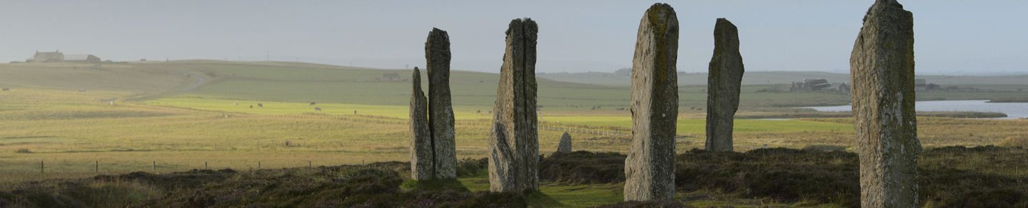
Setting out from the high ground at Ness’s north-western end, the 21st century traveller begins at the Ring of Bookan, passes through a wall and ditch (the Dyke of Sean) to reach the Ring of Brodgar.
From there, it is onwards to the Ness complex and its two (now buried) boundary walls before crossing the water to reach the Stones of Stenness.

Can the presence of all these monuments be just a coincidence? Archaeological evidence suggests not. The single entrance at the Stone of Stenness faces north-west towards the Ness and the Ring of Brodgar causeways align north-west/south-east along its length.
These, together with the known entrances in the Dyke of Sean and the “Great Wall”, suggest that movement along the Ness was, at one point in time, significant and controlled. Why, and by whom, we do not know but it seems that as the Neolithic progressed, travelling the length of the promontory was more than a simple stroll.

That there may have been an earlier path that was monumentalised and partially enclosed is suggested by the location of the Ring of Brodgar. The fact the stone circle, the last great Neolithic construction on the Ness, was not constructed on top of the ridge running along the isthmus suggests something more than visual prominence was required. Instead it was built on sloping ground to the north. Why?
Unlike the Stones of Stenness, which may have been constructed on the site of an earlier building, geophysics scans of the Ring of Brodgar interior have produced inconclusive evidence of internal features. So if it wasn’t enclosing a structure or earlier monument, what was the Ring of Brodgar referencing?
The two opposing causeways at the Ring of Brodgar have long suggested the stone circle was meant to be moved through. Then, excavation in 2008 noted “small flattened ridges” running from both causeways, prompting the archaeologists to ponder whether:

Monumental processional ways are found elsewhere in Neolithic Britain, where they fall under the antiquarian catch-all term, cursus.
Although they seem to be absent from Orkney, cursus monuments are usually long, rectangular earthworks defined by banks, ditches, pits or posts. Dating from the early Neolithic, c3600BC, they can run for miles across a landscape, but a lack of material evidence has made their interpretation difficult.
Although we must not assume that all cursus monuments served the same role, there are common elements. They are often located near rivers or water and seem to have connected separate monuments and/or natural features — both visibly and physically linking them.
Again, we have to be careful assigning blanket interpretations to a group of monuments that varied greatly in their architecture, but one of the possible roles for cursus is that they represented enclosed or bounded routes — perhaps formalised versions of pre-existing paths, tracks or sections of ritualised processions.
Going strictly by archaeological typology, the Ness of Brodgar cannot be considered a cursus. It lacks the banks, ditches, pits or posts that define the monument. Remember, though, that on both sides of the Ness the Neolithic low ground, and the archaeology on it, now lies under water.
Consider these definitions of cursus:
- “Many of the monuments incorporate features of the natural landscape — perhaps already drawn into the social lives of earlier peoples…creating locales which later monumentality formalised.”
- “The linear nature of these sites suggests they guided movement and that movement often led to water.”
- “The activity…contained and controlled was entangled with the natural landscape which inspired ritual activity…”
- “Natural features drew humans to exploit them because of their shape, properties or positions in the landscape, or were appropriated into ritual complexes and monumental alignments. This extended to the inclusion of natural features into pathways…through building enclosures around them or embellishing them.”
Could all four not apply equally to the Ness of Brodgar peninsula?
Perhaps there was no need to artificially define a processional route when there was a natural, ready-made, axis of movement across the landscape. Ditches and banks were perhaps superfluous when the isthmus was already enclosed by water – or wet ground – on three of its sides.
And water is another feature the Ness of Brodgar shared with cursus monuments.
Noting a recurring link between cursus, rivers and water, Dr Kenneth Brophy has suggested the earthworks may be representations of rivers. Among the many layers of symbolism this carries is the idea that just as a river can only flow in one direction, the construction of a cursus may have imposed a “correct” direction of movement across the land.
The idea of “correct” movement may seem strange to us now, but in Orkney it was not that long ago something similar fell out of use. To move, or do anything, “against the sun” — i.e. anticlockwise — was taboo. This superstition was an integral part of daily life and not restricted to rites of passage such as births, marriages and funerals.
While Orkney has no rivers, remember the first farmers were arriving in the islands from the Scottish mainland, or beyond, around 3600BC. Were the ideas behind the demarcation of land and water with cursus monuments carried with them and perhaps transplanted on to what appeared to be a natural, pre-existing processional way?
To Kenneth Brophy, cursus monuments linked “experiences of land, water and previous human activity” — something they clearly shared with the Ness of Brodgar.
Many Neolithic cursus cross streams or have a watercourse at, or near, their end point. As we have seen, the Ness of Brodgar is bisected by the Dyke of Sean, and, in the ditch along its base, the stream known as the Sean burn.


The area of standing water around the Dyke of Sean and the burn has not been archaeologically investigated. We do not know whether it existed in prehistory or is a more recent development due to changing water levels and drainage.
If, for the sake of argument, it existed in the Neolithic, was the water considered special because it came and went?
The winding route of the Dyke of Sean has always been a puzzle. The boundary walls flanking the Ness complex cut straight across the promontory.
The Dyke of Sean, in comparison, snakes erratically from loch to loch. Was the meandering dyke and ditch constructed to control, or manipulate, the route of the burn and create a third river-like boundary — wall, ditch and water?
As a group of islands, Orkney is naturally bounded by the sea.
In island life, water is both a barrier and the means of transport. It contains, protects and connects. Water sustains life and takes it away. It represents the unknown – the unseeable. Another world that, in historical times, was populated with deities, spirits, creatures and monsters. Was it any different in the Neolithic?
Water also defines boundaries. Streams, inlets, bays, lochs and wells have long been used to divide the landscape and incorporated into geographical constructs such as parish boundaries and visible limits of land ownership or use. As a result, overland journeys between “territories” are often punctuated by water crossings.
A fine example today is moving from the parish of Stenness to Stromness — a transition marked by passing over water at the Brig o’ Waithe. Up until the 19th century, moving from Stenness to the neighbouring parish of Sandwick required two water crossings — at the Brig o’ Brodgar and again at the Dyke of Sean.
These water crossings have little significance now but remained firmly in the Orcadian psyche as late as the 19th century and, in some areas, perhaps later. As we have already seen, the Burn of Sean was once regarded as the protective boundary over which the dangers haunting the Ring of Brodgar could not pass.

The concept of water as a boundary in Neolithic Orkney has been suggested before. Professor Colin Richards has argued that the ditches around the Stones of Stenness, Maeshowe and the Ring of Brodgar were all water-filled — at least some of the time — further restricting access to the interior of the monuments, physically and symbolically.
That water was significant in the Neolithic is suggested by the deposition of objects in rivers, lakes, pools and marshes — a practice that continued right through to the Iron Age.
These watery places may also have played a part in the disposal of human remains. They were locations where the dead were “transformed” (i.e. decayed) and perhaps prepared for their onward journey, both physically and spiritually.

Obviously, we cannot say for sure what water represented to the people of the Neolithic but based on available evidence Colin Richards suggests it may have been a “potent symbol” of transformation and separation.
As such, movement across water-filled ditches could be regarded as journey across water “which may have embodied aspects of purification and separation” or associated with personal transformation in rites of passage.
Just as the pools at the north-eastern end of the Dyke of Sean are not permanent — they come and go – the same may have been the case in the ditches around the Ring of Brodgar, Stones of Stenness and Maeshowe. If, as Colin Richards suggests, they contained water, the times of year it was present may have dictated when the monuments were the focus of, perhaps seasonal, activity.

Depending on the direction of your journey, the Ness of Brodgar begins, or ends, at the point where the Stenness and Harray lochs meet. Today, a bridge crosses this point.
Writing in 1851, Lieutenant Thomas explained that until recently it was “stepping stones” that allowed the water to be crossed dry-shod. It was only shortly before the lieutenant’s visit to the Ness, these had been superseded by “a sort of bridge-causeway”.
Applying his theory of domains of the living and dead from Stonehenge/Durrington Walls to the Stenness area in 2000, Mike Parker Pearson questioned whether the watery meeting point of the two lochs was, like the River Avon, a boundary between the dead and the living.
That idea, however, has since been dealt a double blow – first the discovery of the Ness of Brodgar complex in 2003, deep in the hypothesised domain of the dead and then doubt cast on whether water actually separated the Ness from the Mainland in the Neolithic.

Survey work has in the Stenness loch has suggested it was much smaller in the Neolithic and because we do not know with any certainty the situation with the Harray loch, it is impossible to say whether the tip of the Ness peninsula ended at dry land, damp marsh or water — or a seasonal combination of all three.
That the Harray loch did exist – although was smaller and shallower – is suggested by micromorphological analysis carried out during the excavation of the Barnhouse Neolithic settlement. This revealed the regular use of silty clay that the excavators proposed came from the bed of the adjacent loch.
The fact that the Watchstone, and its long-gone companion, marked the threshold of the crossing to the Ness of Brodgar does hint at some former boundary. Or are we looking in entirely in the wrong direction and that the “correct” route to and from the Ness involved passing between the two standing stones and along a pathway now submerged beneath the Loch of Stenness?

If, on the other hand, there was a physical boundary – be that water, marsh or perhaps just a stream, was this a line that was not meant to be crossed? Did the Ness complex lie at the end of the route along the peninsula and not the beginning?
Like the end-point of a cursus and the backslabs within the deepest chambers of the stalled cairns, was the Ness complex the ultimate destination, through which few were able to pass?


