
Skara Brae

By Sigurd Towrie

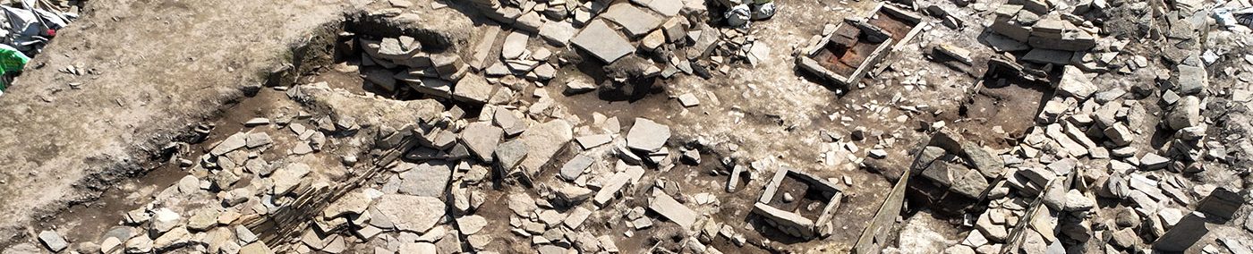
Long hailed the best-preserved Neolithic village in northern Europe, Skara Brae sits at the southern end of the Bay of Skaill, in Orkney’s West Mainland – around 5½ miles, as the crow flies, north-west from the Ness of Brodgar complex.
Located in the midst of a landscape rich in archaeology, thousands of visitors flock to the site annually to view the consolidated remains of ten 5,000-year-old dwellings.
Cocooned by sand for millennia, Skara Brae’s buildings, and their contents, are incredibly well-preserved.
Not only are the walls still standing, and passageways roofed with their original stone slabs, but the interior fittings of each house give an unparalleled glimpse of life in Neolithic Orkney.
This is three-dimensional archaeology at its finest.
Discovery and excavation
Around 1850 [1], a violent storm, together with an exceptionally high tide, undermined part of the dunes at “Skerrabrae” [2] to reveal an artefact-filled “kitchen midden”. [4]
Investigation by William Watt, “who resided at Skaill”, suggested “the existence of extensive buildings”. [4]
Watt wasted no time before digging into these and, by February 1851, it was clear there was “a small ruinous chamber” within an “immense accumulation of ashes, several feet in thickness, plentifully mixed with shells and the horns and bones of deer and other animals”. [5]
By 1868, four structures and had been revealed, together with a “vast hoard of primitive relics”. [6]
Although Watt’s work was carried out “with loving care and almost with his own hands” [7], it was excavation only in terms of the dictionary definition. Were it not for the Orcadian antiquarian George Petrie’s plans and records of the site, documentation would be non-existent. [8]
In July 1861, the visiting MP James Farrer took time out from his operations at Maeshowe, the Ring of Brodgar and the mounds around the stone circle, to get stuck into one of the Skara Brae mounds.
There he “caused several chambers and passages to be opened” but was clearly not satisfied with what he found, declaring that “I do not think anything is likely to result from further excavations at Skaill…” [8a]
He then turned back to what he is now infamous for – mound-breaking:
In typical Farrer fashion, however, we do not know which tumuli he was referring to or whether there was “anything worth of record”. Presumably not.
‘A complete fiction’?
According to the Orcadian historian Dr Ernest Marwick, the idea that Skara Brae was unknown until 1850 was “a complete fiction”. [8b]
In a 1967 article in The Orcadian newspaper, he wrote:
Marwick was wrong.
Firstly, Robertson was a visitor to Orkney and there is no place called the “Downs of Skail”.
Secondly, references to these “square catacombs” appear in numerous early accounts, which place them, correctly, on the Links of Skaill, around half a mile north-east of Skara Brae. For example, in the earliest, from 1693, Rev James Wallace wrote:
As is shown here, the area around the Links of Skaill and the hill, Sandfiold, was covered in with visible mounds in the late 18th century.
And still is.

At least five were opened during “grave digging” explorations in the 1770s. The records of these led to the suggestion that they were Bronze Age cist burials.
However, agricultural work in 2021 revealed another fine example of a cist burial, a short distance from those opened in the 18th century. Excavation revealed the well-preserved remains of an adult male, in his mid 20s, with no grave goods.
Radiocarbon dating has confirmed this burial was not Bronze Age but Late Neolithic [3] and therefore contemporary with Skara Brae, the Ness of Brodgar and the Barnhouse settlement.
Although full details have yet to be published, the discovery could go some way to explaining the Neolithic dates from the Sandfiold cist, discovered in 1989 and subsequently excavated.

However, the burial described by Roberston in 1769 is clear that the remains had “a sword in one hand and a Danish axe in the other” – which clearly can’t be Neolithic or Bronze Age.
But Robertson’s description is identical to Wallace’s 1693 account of a (presumably) Norse burial at the Links of Trenabie, in Westray. Was he getting his Links mixed up? I suspect so.
Why?
Because in 1773, just four years after Robertson’s visit, Rev George Low had no knowledge of any such find at the Links of Skaill. A minister of the kirk in Stromness, Low himself had participated in the Sandfiold “grave digging” and stated:
He added:
If Robertson’s account was correct, it could be explained by the fact there was Norse activity on the low ground between Sandfiold and the Bay of Skaill. How do we know? Because an 11th/12th century longhouse was excavated there by Oxford University 2005-2008).
That, however, does not explain Low’s ignorance of the find.
Back to Skara Brae…

(📷 Orkney Library Photographic Archive).
After Watt, the initial flurry of activity around Skara Brae waned and the site left to the elements for at least 45 years.
It was revisited in 1913, when William Balfour Stewart’s “unmethodical excavations” [9] seem to have simply cleared out previously investigated areas. The site was then left until 1925, when another storm damaged some of the exposed archaeology.
A sea wall was raised and it was decided that the building remains should also be consolidated. A side benefit of this was an excavation, led by Professor Vere Gordon Childe, which ran from 1927 until 1930.
Childe set to work “clearing out” the buildings [10] and “was reasonably successful” [11], in uncovering “an agglomeration of stone huts connected by covered passages and all partially buried in a huge midden heap”. [12]

Childe’s interpretation of the site saw him create an inaccurate, but tenacious, vision of Neolithic life that remains in some quarters today. Perhaps the most persistent was the the sudden and “hasty desertion” of the settlement in the face of an apocalyptic calamity.


Childe originally thought Skara Brae represented an Iron Age settlement (early centuries AD) based on correlation be believed existed between the carved stone balls found and the Pictish symbol stones encountered across Scotland. [13]
Some years later, when it became clear that the pottery was much earlier [14], Skara Brae was pushed back two millennia, firmly into the Neolithic.

Radiocarbon dating in the early 1970s confirmed that the settlement was Neolithic, the dates secured suggesting the excavated section we see today was inhabited between 3200BC and 2200BC.
In December 1999, it was confirmed that Skara Brae had been included in the Heart of Neolithic Orkney World Heritage Sites by UNESCO.
See also
- Interactive 3D Model: House Seven, Skara Brae
- Interactive 3D Model: House One, Skara Brae
- Interactive 3D Models: Skara Brae artefacts
Notes
- [1] Every late 20th century account places the storm that revealed Skara Brae in 1850, but the earlier sources are less clear. Hugh Marwick placed it “in the year 1850, or immediately before…” (1929) while George Petrie was equally vague: “About fifteen or sixteen years ago…” (1867). Depending on when Petrie wrote his paper, this places the storm between 1849 and 1851.
What is without doubt is that by February 1851, Lieutenant Thomas had documented that there were archaeological remains on site. - [2] Skara Brae is a modern corruption of Skerrabrae or Skerrabra – the names by which the site was known until at least the 1950s. Writing in 1928, the Orcadian scholar Hugh Marwick explained: “An elderly Sandwick man, who has lived in the neighbourhood all his days, informs me that he had always hear it referred to as ‘Styerrabrae’, i.e. Skerrabrae, with the local palatalising of ‘sk’ before a front vowel.”
- [3] Skara Brae Statement of Significance. Historic Environment Scotland 2024.
- [4] Marwick, H. (1929) Skerrabrae. In Proceedings of the Orkney Antiquarian Society, Volume VII (1928-1929), pp 17-26. The Orcadian: Kirkwall.
- [5] Thomas, F. W. L. (1851) XIII — Account of some of the Celtic Antiquities of Orkney, including the Stones of Stenness, Tumuli, Picts-houses, &c., with Plans, by FWL Thomas, RN, Corr. Mem. SA Scot., Lieutenant Commanding HM Surveying Vessel Woodlark. Archaeologia, 34(1), pp.88–136.
- [6] Petrie, G. (1867). Notice of Ruins of Ancient Dwellings at Skara, Bay of Skaill, in the Parish of Sandwick, Orkney, recently excavated. In Proceedings of the Society of Antiquaries of Scotland (Vol. 7, pp. 201–219).
- [7] Old Lore Miscellany (1909).
- [8] It was solely due to Petrie’s plan that Gordon Childe, who excavated Skara Brae in the late 1920s, realised that House One had been “restored” by Watt.
- [8a] Farrer, J. Letter to The Orcadian newspaper, July 27, 1861.
- [8b] Marwick’s was not the only attempt to push the discovery of Skara Brae back a few centuries. Others have focused on the 1716 edition of Martin Martin’s A Brief Description of the Isles of Orkney and Schetland, which states:
“About a Mile to the West of the Mainland at Skeal-house (sic), there is in the top of high Rocks many Stones dispos’d like a Street, about a quarter of a Mile in length, and between twenty and thirty Foot broad.”
This has been argued to be evidence that elements of Skara Brae were visible at least 150 years before the storm exposed the site – despite the clear discrepancy in the given measurements. What Martin was actually describing, however, is a geological feature encountered on the clifftops between the Head o’ Rowe and Borwick. These incredibly straight outcrops look to be made up of regularly sized and set stones, giving them the appearance of beautifully made drystone walls.
Again, Martin’s entry is almost identical that found in Rev James Wallace’s 1693 A Description of the Isles of Orkney, the difference being that Wallace’s full entry confirms he had no doubt it was natural feature:
“At the West-end of the Mainland, near Skeal, on the top of high Rocks, more than a quarter of a Mile in length, there is something like a Street all set in red Clay…having the Images and Representations of several things, as it were, engraven on them;” - [8c] Rev George Low. Letter to Mr George Paton. June 1773.
- [9] Childe, V. G. (1931). Skara Brae: a Pictish village in Orkney. Kegan Paul: London.
- [10] Childe, V. G., Paterson, J. and Bryce, T. (1929). Provisional Report on the Excavations at Skara Brae, and on Finds from the 1927 and 1928 Campaigns. With a Report on Bones. In Proceedings of the Society of Antiquaries of Scotland (Vol. 63, pp. 225–280).
- [11] Ritchie, A. (1995) Prehistoric Orkney. Batsford Ltd: London.
- [12] Childe, V. G. (1931). Skara Brae: a ‘Stone Age’ village in Orkney. Antiquity, 5(17), pp.47–59.
- [13] Childe, V. G. (1930) Operations at Skara Brae during 1929. In Proceedings of the Society of Antiquaries of Scotland (Vol. 64, pp. 158–191).


