
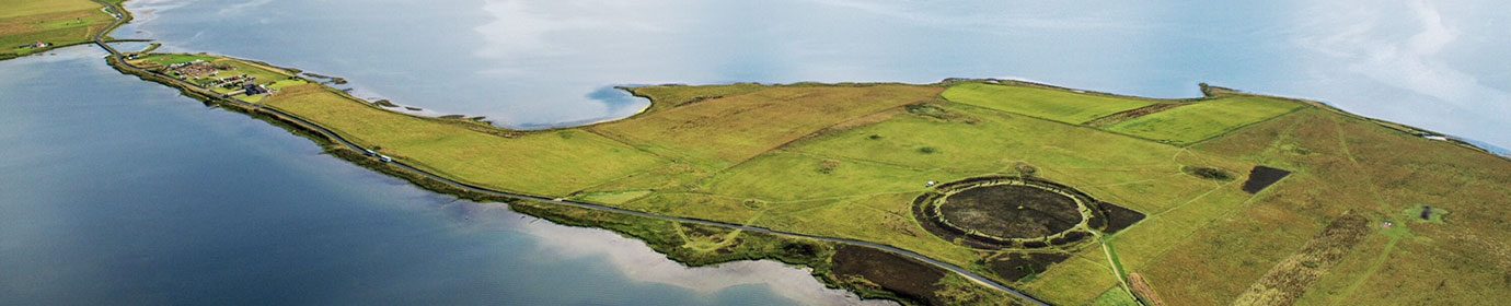
Toftsness Neolithic settlement, Sanday
By Sigurd Towrie

Archaeological remains at Toftsness, the peninsula at the north-eastern end of Sanday, had been known about for centuries.
Not only were there multiple mounds but walling, apparent structural features visible. Artefacts found on site also made it into the records.
As a result, Toftsness was the second Sanday settlement investigation carried out in the 1980s. By that time, the complex comprised a series of banks, enclosures, seven large mounds and over 300 smaller mounds and cairns.
Between 1985 and 1988, using a combination of selective excavation and geophysical survey, a team from the University of Bradford revealed a domestic and funerary landscape and multi-period settlement spanning the Neolithic through to the early Iron Age. [1]

(📷 Dockrill et al. 2007)
Like Pool, the Toftsness excavation focused on a single, large mound. This one, Mound 11, was being badly damage by rabbits. Measuring approximately 60m by 20m, it represented a small, nucleated settlement that probably housed an extended family group. [2]
Because the sole Neolithic structure encountered sat on top of anthropogenic soil dating to 3360–2920BC — the excavators considered it unlikely to represent the earliest activity on site. [2]
Christened Structure One, little remained of the four-metre-diameter, sub-circular building and of the internal features, only the hearth survived (ibid). The interior appeared to have been remodelled in later life [3] but the fragmentary condition of the remains made further interpretation impossible.
Radiocarbon dates suggested Structure One was constructed between 3350BC and 2970BC and went out of use between 3270BC and 2910BC. [3]
The scant remnants led to the suggestion that the building was robbed out in the Late Neolithic, the stone re-used in a phase “not represented in the excavated area”. [2]

(📷 Dockrill et al. 2007)
Therein lies the problem with Toftsness — a major component of the excavation strategy was to preserve the southern, uneroding, section of the mound, which prevented a full investigation of the extent and nature of the structural remains. [1]
As a result, we do not have a complete sequence and the full development of the site is not well understood.
What is clear is that after Structure One went out of use, midden-rich soil was used to cover it its remains. [2]
To the excavators the burial of the building, around 3110–2860BC [3], marked the start of the final phase of Neolithic activity, which saw the bulk of its stone “systematically removed”. [2]
They interpreted this dismantling as simple robbing to secure stone for construction outside the excavated area [2]. I wonder, however, whether we have another example of a building being dismantled/left to decay before being deliberately sealed in midden — a process encountered at the Ness of Brodgar and the Links of Noltland..
Whatever the reason, the final Neolithic phase saw Structure One gradually enclosed by midden material from a hypothetical settlement area to the east [2]. This phase ended in 2860–2660BC, a date “broadly contemporary with [the end of] other Grooved Ware sites in Orkney”. [3]
The Toftsness excavation results were hailed a first for Orcadian Neolithic settlement studies as they showed evidence of continual occupation from the late fourth millennium cal BC through to the mid-second millennium cal BC – thus spanning the Neolithic-Bronze Age horizon. [2]
This Sanday site differed from other Orcadian Neolithic settlements in other ways, not least a lack of Grooved Ware pottery. Although the first activity at Toftsness was contemporary with the Grooved Ware phases at Pool, there was a noticeable absence of the ceramic style at the northern site. [2]

The excavators looked to a social hierarchy as an explanation, suggesting the excavated section of the site was of lower status than a hypothetical primary settlement on high ground to the south-west. [2]
They suggested Grooved Ware was a specialised ceramic form associated with status [3] and its absence was perhaps because the Mound Eleven inhabitants were excluded from using it. They conceded, however, that Grooved Ware may have been deposited elsewhere on site – a situation also noted at Barnhouse.[4]
The consensus of opinion was that status taboos surrounding the use of Grooved Ware were more likely than a “different cultural tradition in such a small island”. [3]
The similarities between later Neolithic ceramics at Toftsness and assemblages from Shetland [2] is important. Do we have a situation where a marginal settlement had more in common with its northern neighbours than the rest of Orkney? It is perhaps time that we looked beyond the constraints imposed by the geographical label of “Neolithic Orkney”.
While hardly conclusive evidence for Shetland links, a single sherd of steatite from the late Neolithic phase at Toftsness does confirm contact with Shetland – the nearest source – before the Bronze Age. [2]
Notes
- [1] Dockrill, S. J. (2007) An introduction to the research. In Dockrill, S., Bond, J. M., Nicholson, R., and Smith, A. (eds) Tofts Ness, An Island Landscape through 3000 years of Prehistory: Investigations in Sanday, Orkney Volume 2. Kirkwall, The Orcadian, in association with Historic Scotland: Kirkwall, pp. 1–12.
- [2] Dockrill, S. J. (2007) Discussion. In Dockrill, S., Bond, J. M., Nicholson, R., and Smith, A. (eds) Tofts Ness, An Island Landscape through 3000 years of Prehistory: Investigations in Sanday, Orkney Volume 2. Kirkwall, The Orcadian, in association with Historic Scotland: Kirkwall, pp. 381–396.
- [3] Dockrill, S. J. (2007) The Neolithic and Bronze Age. In Dockrill, S., Bond, J. M., Nicholson, R., and Smith, A. (eds) Tofts Ness, An Island Landscape through 3000 years of Prehistory: Investigations in Sanday, Orkney Volume 2. Kirkwall, The Orcadian, in association with Historic Scotland: Kirkwall, pp. 13–40.
- [4] Jones, A.M. and Richards, C. (2005) Living in Barnhouse. In Richards, C. (ed) Dwelling among the monuments: the Neolithic village of Barnhouse, Maes Howe passage grave and surrounding monuments at Stenness. Cambridge: McDonald Institute for Archaeological Research, pp. 23-56.


