
The Sandfiold Bronze Age cemetery

By Sigurd Towrie

Sandfiold [1] is a low hill in the parish of Sandwick that overlooks the Bay of Skaill, directly to its west.
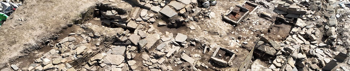
Lying just over half a mile to the north-east of Skara Brae, the area around the hill is home to the remnants of what appears to be an extensive Bronze Age cemetery that probably dates from between 2300-1700BC [8].
Discoveries around Sandfiold include “an exceptional” cist in 1989 and an incredibly well-preserved cist burial in February 2021.
This, the first of three articles, focuses on the cemetery, which was targeted by 18th century “grave-diggers” who encountered artefacts and human remains during their jaunt.
From Rev James Wallace’s 1693 account (quoted above) it is clear that rectangular stone features were known at the Links of Skaill – the area between the bay and Sandfiold – in the late 17th century.
What is not clear is whether Wallace knew their purpose. The fact he likens them to similar features from the island of Stronsay suggests suspected a funerary role, although from the wrong historical period.
The Stronsay “monuments”, he wrote, were likely to be “ancient urns wherein the Romans, when they were in this country, laid up the ashes of their dead.” [2]

Less than a century later there was no doubt and at least five episodes of “grave-digging” [3], as it was termed, occurred in the shadow of Sandfiold. Involved in at least one of these was Rev George Low, who was a church minister in Stromness. [3]
In a 1773 letter accompanying the above illustration of “the ancient graves found in the Orcades”, Low explained to his correspondent that: “These figures were taken from some opened in the Links of Skail [3], on the mainland…”
A plan of the area drawn up at this time (pictured below) shows mounds of varying sizes covering the links but particularly concentrated around the gentle slopes of Sandfiold.
Given the sheer number shown on the Walden map it is highly unlikely that people were unaware of the barrows.

That said, knowledge of their existence may have actually helped protect the archaeology – from most casual diggers, at least. Howes and knowes (mounds) had the fearsome reputation of being the dwellings of supernatural creatures and as late as the early 20th century tended to be avoided where possible.
Low and his colleagues, however, had no such fears.
A naturalist, Low had moved to Orkney between 1766 and 1768, where he became a tutor to the family of Robert Graham of Skaill. The Links of Skaill was owned by the Graham family, who had used the area as a golf course in the 17th century. [4]

Low’s involvement in the early “excavations” was brought about by a visit to Orkney by Sir Joseph Banks in 1772. Banks, a celebrated naturalist, was touring Iceland and the Scottish Northern Isles and appointed Low director of the Orkney leg.
He wrote:
Inside the cist the investigators found the remains of a crouched burial, apparently in such a good state of preservation that flesh – or parts of it – had survived.
Based on the teeth, Low declared it to be an elderly man. At “his” feet was a bag containing disarticulated human remains. [3]
Low continued:

Describing the “several” which had been opened, Low explained that:
Around the cist “is built a number of common rough stones, and over all a heap of sand, shaped like a flat cone; which is the appearance they have to the eye.” [3]
The opened graves seen by Low contained no pottery or burnt bone, but only entire skeletons “laid in no determinate posture, some being found sitting, and others lying on their sides.” [3]
One of the cists, however, produced the beads “made up so as to be worn about the neck” [3] – In the spirit of antiquarian investigation, Low set one on fire to test its composition.
“I have seen several of the beads,” he wrote, “they are black and seem to be made of a sort of cannel coal, they burn well, emitting a strong white flame, and a white cinder remains.” [3]
The beads presumably came from one of three cists opened the same year by Robert Graham of Skaill, who described his findings in a letter to the Scottish antiquarian Robert Ramsay. [5]
Graham found “about 200 small black beads” in a cist that also contained “some human bones lying in the widest end, in the other a great many burnt bones”. The “burnt ashes” he added, had “some kind of covering, which appears to be made of hair…” [5]
This “hair” was undoubtedly the remains of a organic material – perhaps a mat similar to that encountered in the excavation of the nearby Sandfiold cist in 1989.
The black beads appear to belong to a typical Bronze Age bead necklace, which date to c2200-1700BC [6]. Among these was “a piece of bone which take to have been Ivory, but the colour much altered, [and] from a hole being in it we conclude to have been a locket”. [5]
Based on similar artefacts from Scottish sites, Mamwell has suggested that the flat, lozenge-shaped object was a toggle fastener from a funerary garment and dates from 2300-1600BC [6]. The fact it was discoloured suggests it had been on a cremation pyre along with the body of the deceased. [6]
It is also clear from Graham’s account that the burial cists varied in size and content. Although the above example contained only disarticulated and burnt bone, the two others held complete articulated skeletons:
In another he found “the bones of a child whole and entire lying on its side with its knees a little bended, as people generally lie in bed.”
Graham wrote:
The variety of inhumations was also highlighted by Low.
Describing the main subject of his illustration (picture above) he explained:

The only other surviving account of the expedition, written by Banks’ personal servant James Roberts, introduced a new element – the apparent giant size of the articulated skeleton described by Low:
Where the people buried around Sandfiold lived remains elusive. Geophysical survey to the south-west suggests some settlement, but “the character and density of Bronze Age occupation has yet to be determined.” [8]
Whether the 18th century incursions into the Bronze Age burials were the last is not known.

If more were opened the operations were not documented.
While some of the “immense abundance of tumuli” noted by Banks in 1772 were probably affected by agricultural improvement in the 19th century [6], it may be that a substantial number survived on Sandfiold’s upper slopes.
Not only was an apparently reusable, cist-type feature found on Sandfiold in 1989, but a large stone cist, discovered during agricultural work in February 2021, contained the perfectly preserved remains of an adult male, interred in a foetal position but with no grave goods.
The next article looks at the former in more detail.
Notes
- [1] From the Old Norse meaning “sand hill”.
- [2] Wallace, J. (1693) A Description of the Isles of Orkney.
- [3] Low, George (1879) Tour through the islands of Orkney and Schetland in 1774. (Ed. Joseph Anderson) Kirkwall, 1879
- [4] Wilson, B. (2013) Stromness: A History. The Orcadian: Kirkwall.
- [5] Lysaght, A.M. (1974) Joseph Banks at Skara Brae and Stennis, Orkney, 1772. Notes and Records of the Royal Society of London, 28(2), pp.221-234.
- [6] Mamwell, C. (2018) It rained a lot and nothing much happened: Settlement and society in Bronze Age Orkney. PHD thesis.
- [7] Graham referred to the burials as “urns”: “I have discovered several Urns, as we call them here; how properly we call them so I cannot say.”
- [8] Brend, A., Card, N., Downes, J., Edmonds, M. and Moore, J. (2020) Landscapes Revealed: Geophysical Survey in the Heart of Neolithic Orkney World Heritage Area 2002-2011. Oxbow Books, Oxford.


