
Enclosing the midden mound – Iron Age activity at the Ness excavation site

(📷 University of Aberdeen: George Washington Wilson photographic archive)
By Sigurd Towrie
Although the Ness of Brodgar is best known for its Neolithic archaeology, the isthmus was a focus of activity throughout prehistory and history.
The Ness complex was abandoned at the end of the Neolithic, around 2500BC, but at least one section was brought back into use, some 1,800 years later, in the Iron Age.
Near the south-eastern tip of the Ness is a huge mound of what we now know to be occupational refuse – rubbish deliberately dumped during the Neolithic.
With a diameter of c.70 metres and at least four metres deep, this mound is still visible for miles around. In its heyday, however, it must have been as imposing as the monumental structures that stood to the north-west.
Today, however, the midden mound is a shadow of its former self. We know that it remained a major landmark until the 1880s, when the field was partially quarried, levelled and squared off. This operation reduced it in height and obliterated whatever structural remains survived on the summit.

(📷 University of Aberdeen: George Washington Wilson photographic archive)
In Magnus Spence’s 1907/08 account of Orkney’s bonfire traditions the Ness mound was still imposing enough to warrant a very brief mention. Spence did, however, give its name and informed his readers that ash and burnt stone lay on its surface.
Like most Orcadian placenames, Kok-na-cumming is simply descriptive.
Kok, in Orcadian dialect, means heap, usually in reference to seaweed. Here it may relate the mound itself. Cummeen (Orcadian pronunciation of Cumming – compare to Cuween/Kewing in Firth), I would argue, was the name of the field, incorporating kummle, a mound or prehistoric site showing evidence of some old burial or memorial structure, and eng, a meadow.

Visiting in 1848, Lieutenant Thomas shows the “tumulus” on his map of the Ness of Brodgar: describing it in his 1851 publication, Account of some of the Celtic antiquities of Orkney:
Because of its size, the Ness mound had long been thought to contain a Neolithic chambered cairn. Geophysical survey revealed clear anomalies about halfway up the mound’s slope and their concentric nature led to the suggestion they represented a broch-like structure. This was superceded by the idea that the circular anomalies may relate to the retaining walls of a Maeshowe-type chambered cairn.

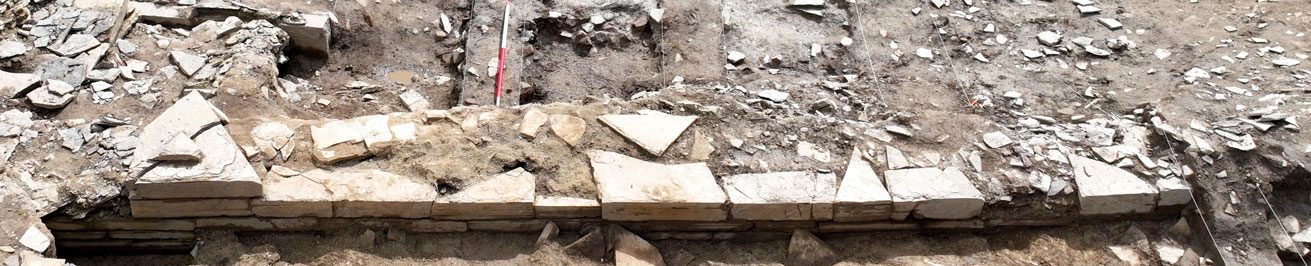
To investigate, Trench T was opened on the mound in 2013. Before long it became clear that the circular anomalies were not Neolithic in origin but were stone revetment walls that defined an Early/Middle Iron Age ditch dating from some time between 700BC and AD200.

Excavation revealed that the flat-bottomed ditch had been cut into the upper slopes of the Neolithic midden mound, enclosing the top. Inside was evidence for a three-metre wide revetted bank. Under the bank were two human teeth and a toebone.
At the end of its life the ditch had been filled in with a huge volume of rubble.

A 19th century survey of the area by Orcadian antiquarian George Petrie and Sir Henry Dryden, a regular visitor to Orkney, suggests the ditch was continuous, enclosing an area c.35 metres in diameter.
This was backed up by geophysics results, which also suggested there was an entrance on the south-eastern side, facing the Brig o’ Brodgar, the Stones of Stenness and the putative broch at Big Howe.
Why dig a ditch and raise a bank on top of the mound? What were the Iron Age builders enclosing?
Petrie and Dryden’s 1851 survey suggests a circular stone construction, c.12 metres in diameter, once stood at the centre of the enclosure – something also corroborated by the modern geophysical survey results.
The fact that a recognisable structure survived on top of the mound until the mid 19th century also fits with the use kummle placename element – “a mound or prehistoric site showing evidence of some old burial or memorial structure”.
We do not, however, know what this circular structure was.
All we can say for certain is that it was too small to be an Iron Age broch and that elements of it survived until at least the 1850s. Although Iron Age pottery fragments were found in the ditch fill, it was not enough to suggest any prolonged occupation.

(📷 Sigurd Towrie)
Although not on the same scale, the remodelling of the Ness midden mound shares features with Minehowe, an Iron Age site in Orkney’s East Mainland.
Here an underground chamber was inserted into a natural glacial mound and enclosed by a huge, monumental ditch.
Ditches in the Iron Age probably served the same purpose as their Neolithic predecessors – they created and demarcated a physical “place” detached from the surrounding landscape. They controlled movement and access and not only excluded the ordinary, everyday world but contained the interior and whatever it held.
Three-hundred metres to the south-west of Minehowe is a closer parallel to the Ness ditched enclosure. Until its excavation in 2003, Roundhowe was considered to be the remains of a small, but “greatly mutilated”, broch surrounded by a large ditch.
Excavation showed that this was no broch, although it remains unclear what it actually was. A bank once stood within the ditch, which was dated to the Late Bronze Age/Early Iron Age. As at the Ness of Brodgar, there was no evidence of occupation at Roundhowe – in fact there was little evidence of use whatsoever.

Whatever the Iron Age construction at the Ness of Brodgar represented there is no doubt that it was – and was meant to be – highly visible. Siting the monument on the south-eastern end of the Ness of Brodgar must also have been significant given the isthmus’ role as a route between the lochs of Harray and Stenness.
Aside from its prominence, the site probably selected because of its association with the past – a past that was already ancient to the Iron Age builders.

The reuse of Neolithic buildings in the Iron Age is not uncommon and we know that Iron Age Orcadians continued to use, and respect, earlier prehistoric sites.
A fine example is the Quanterness chambered cairn where a roundhouse was built into the front of the Neolithic structure. Here the Iron Age builders not only incorporated the earlier building into theirs but took great care not to disturb the original entrance.
But by the time we excavated the top of the Ness mound, there was no trace of any Iron Age feature or structure. Whatever once stood there has, unfortunately, been lost to history. But the fact the Ness of Brodgar attracted Iron Age attention should come as no surprise.
Not only do we have the suspected broch site at Big Howe, a short distance away from the Standing Stones of Stenness, but the 1906 operation to re-erect the fallen megaliths within the stone circle produced 51 sherds of Iron Age pottery, dating from between 50BC to AD300.
In addition, one of five pits discovered during the 1973/74 excavations, to the south of the monument’s central hearth, produced a piece of charcoal that was radiocarbon dated to between AD100-1050. This pit is thought to be contemporary to the others, due to the pottery and a stone tool found in those.

In the early/mid 17th century nine silver rings were found in a mound north of the Brig o’ Brodgar. Despite the lack of documented evidence – the rings are now lost – the discovery has become firmly attached to Salt Knowe, to the south-west of the Ring of Brodgar.
Wallace’s A Description of the Isles of Orkney, published in 1693, states:
The fact it specifically mentions the Brig o’ Brodgar and the “circle of high stones” strongly suggests he was referring to the Stones of Stenness and that the silver hoard came from the Ness mound. Why use the brig as a point of reference if you are referring to the Ring of Brodgar?


