
The Stonehall settlement – part two

Stonehall Meadow
By Sigurd Towrie

The section of the Neolithic settlement designated Stonehall Meadow was an area of mounds to the north-east of the Stonehall Knoll.
Agricultural work had greatly disturbed the structural remains, but excavation revealed the presence of four Neolithic structures, three of which were in a poor state of preservation.
Occupation at Stonehall Meadow, like that at Stonehall Knoll, extended over a long period, with episodes of demolition and reconstruction apparent.
House One

House One was the earliest of the buildings in the area and represented solely by a section of wall incorporated into the later House Three. [1]
Aligned roughly north-south, the building was probably sub-rectangular with entrances to the north and east. From the surviving remains, One was reminiscent of House Three at Stonehall Knoll and Stonehouse One at the Wideford Hill settlement.
The building was probably demolished to allow the construction of Houses Two and Three – although the fact that its eastern end was incorporated into Three shows it was not entirely dismantled.
Birch and hazel charcoal from the only two contexts representing House One could indicate its destruction, by fire, of a predecessor and/or its structural features. [2]
House Two

This structure was only partially investigated but, based on its relationship with House Three, was probably also sub-rectangular and aligned north-west to south-east.
Like the buildings at the Knap of Howar, Houses Two and Three were joined, a passage providing access between the two. [1]
Excavation suggested that House Two was raised first, and was freestanding for a period, before Three was built up against its northern wall.
Like House One, large fragments of birch, hazel and willow charcoal within the wall core material suggests earlier structures or features had been burned – although it is impossible to rule out the use of timber as fuel. [2]
A substantial quantity of barley was recovered from the building’s wall core, which must have been sourced from an existing midden dump.
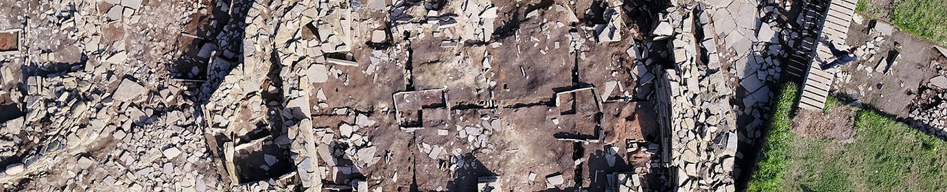
House Three

The best-preserved of the structures, Three was also sub-rectangular, but with a rounded western end that saw it described as “boat-shaped” by the excavation team. Aligned north-west to south-east, it measured around 8m wide by at least 11m long. [3]
The building incorporated the eastern wall of House One into its construction, its predecessor’s original entrance blocked up to form part of Three’s northern side. Access to the building was by an entrance in the east end, which led into a rectangular chamber c4.2m wide by 6.7m long.

A pair of orthostats projecting from the northern and southern walls divided this chamber into two sections. The eastern section, along with the passage connecting House Three to its neighbour, was paved.
This paved half produced a “substantial proportion” of the worked flint found in the area, suggesting that craft activities took place here and on the working area directly outside the entrance. [1]
West of the passage between Houses Two and Three, and lying beneath a flagstone cover, was a stone-bottomed orthostatic box. North of this was a suspected grain storage pit, which contained the largest quantity of barley recorded from the entire Stonehall settlement.
The covered pit was empty except for a silty deposit at the bottom, which contained the grain. Charcoal also present led to the suggestion that the grain pit had either accidentally or deliberately been burned.
The barley deposit returned a radiocarbon date of 3360-3010BC. [1]

The unpaved western portion was dominated by a large oval scoop hearth. Measuring over one metre long, the hearth contained ash that provided a date of 3340-2920BC.
South of the hearth, and against the side wall, were slots to hold stone slabs and perhaps a wooden partition.
While these may represent the remains of a “box bed” feature found in other Neolithic structures, as the excavators stressed it “could just as easily been employed for storage as sleeping.” [1]
A similar feature was noted in the Early Neolithic structure at the Knowes of Trotty.
A drain ran from a pit in the western end, across the middle of the building, past the heath and through the divisional orthostats.
A modern drain had destroyed the west end of House Three but the surviving evidence pointed at the building being extended in a second phase of use. This created a rear chamber, perhaps akin to that encountered within the Knowes of Trotty building.
This chamber was defined by a wall inserted across the rear of House Three. [1]
It has long been proposed that there was a special significance attached to the rear – the innermost area – of later Neolithic houses. This was marked by the construction of the so-called “dressers”, the best surviving examples of which can be seen at Skara Brae. It may be that House Three’s rear chamber was a precursor to this – a sacred, or special, area that “endured, developing into the ‘dressers’ or house altars…” [4]
Presumably added at the same time was a line of paving from the eastern end that crossed the centre of the western end and through an entrance in the new wall.
More often than not, Neolithic dwellings are notable for their exceptionally clean floor surfaces. House Three’s, however, was found to be covered by a thick layer of ash. To the excavators this suggested the building had either been destroyed by fire, or perhaps more likely, had been used for dumping ashes after it had gone out of use.
House Four
A short distance east of Houses One, Two and Three, excavation revealed evidence of more Neolithic structures. These, however, were in very poor condition and only one, dubbed House Four, could be definitely identified as a building.
Four shared the same north-south alignment as House One, but such was its condition that there was little else that could be said about it. Charred barley from an ashy deposit returned radiocarbon dates of 3490-3090BC and 3360-3030BC.
House Four, it was suggested, postdated the ashy material, which may have related to an “undetected, pre-stone, timber phase in the area”. [1]
Differences
The “significant amount” of barley recovered from the wall core of House Two and House Three’s pit is interesting, given the lack of querns in any of the buildings or their environs.
That cereal cultivation was taking place is beyond doubt and the evidence points to it being processed in the Stonehall Meadow area. Although wood and seaweed were being burned for fuel at the contemporary Stonehall Knoll, at the meadow site it seems turf was used. Burning turf produced the “low and level heat necessary to facilitate cereal drying”. [1]
But while grain was being processed, does the lack of querns indicate it was not being ground?
Probably not. It should be remembered that not all the Stonehall site was investigated and not all the discovered buildings fully excavated. In addition, most had suffered badly under the plough. Just as certain activities appear to have been confined to Stonehall Knoll, it may be that the same applied to Neolithic milling.

There is a considerable body of literature looking at the symbolism of querns and their treatment after use. This suggests that quernstones had a significance beyond the merely practical, perhaps acquiring special meaning over time.
At the Etton causewayed enclosure, for example, numerous querns – most broken – had been deposited.
“Certain querns and pottery vessels could well have symbolised the domestic routines and tasks that help to bind communities together. The querns do appear to have been important symbols,” wrote the excavator Frances Pryor.[7]
He added: “It would appear that the intention behind the deposition and breakage of the querns was to remove them from the domestic sphere.” [7]
The deliberate the breaking of quernstones, Pryor argued, may have formed an important part of Neolithic funerary or commemorative rites. [7]
The discovery of quern fragments in other Orcadian Neolithic contexts could also mean they were deliberately broken at the end of their lives, perhaps after being removed from buildings after abandonment.
At the Ness of Brodgar, for example, the few querns that have been found all came from secondary contexts, including pit deposits and incorporated into building walls.
The grain processing at Stonehall Meadow serves to highlight the differences between this area and Stonehall Knoll, where evidence of cereals was notable by its absence.
The differences continue. Not only in the elevated position of Stonehall Knoll, but in the use of space. As we saw at Stonehall Knoll, and going against the pattern noted at other Neolithic Orcadian sites, the construction of the three structures deliberately avoided the footprint of their predecessors.
At Stonehall Meadow, however, the episodes of demolition and construction not only reused the same building sites but incorporated elements of earlier buildings. As regular readers will know, this is suggested to represent continuity – a physical link to the past and those who came before.
Loosely grouped settlement
To the excavators, the three Stonehall Meadow dwellings revealed during the project “were not alone in occupying the lower ground.” [1]
The visitor to Stonehall around 3000BC, they added, would see:
A new architecture

As noted above, the architecture of House One resembled that of the later House Three on Stonehall Knoll and Stonehouse One at the nearby Wideford Hill settlement.
What this tells us is that the orthostatic dividers that were long considered a staple of Early Neolithic house architecture was not present in the earliest buildings at either settlement.
This was a highly significant discovery because it showed that the stalled architecture of the Orkney-Cromarty chambered cairns was a much later addition to Orcadian dwellings.
This was contrary to the long-held belief that stalled cairns were based on domestic architecture, literally “houses of the dead”. Instead, the opposite was the case – cairns were not based on the houses. The housebuilders sought to copy the cairns. [6]
Why? What was the significance of replicating the so-called houses of the dead into that of the living?
The suggestion is again to link to the past, genealogy and ancestry:
Notes
- [1] Richards, C., Brophy, K., Carruthers, M., Jones, A., Jones, R. and Jones, S. (2016) Good Neighbours: Stonehall Knoll, Stonehall Meadow and Stonehall Farm. In Richards, C. and Jones, R. (eds) The Development of Neolithic House Societies in Orkney: Investigations in the Bay of Firth, Mainland, Orkney (1994–2014). Windgather Press, pp. 91-127.
- [2] Miller, J., Ramsay, S., Alldritt, D. and Bending, J. (2016) Bay of Firth Environments from the 2nd to 4th Millennium bc: the evidence from Stonehall, Wideford Hill, Crossiecrown, Knowes of Trotty, Varme Dale and Brae of Smerquoy. In Richards, C. and Jones R. (eds) The Development of Neolithic House Societies in Orkney: Investigations in the Bay of Firth, Mainland, Orkney (1994–2014). Windgather Press.
- [3] Probably 12-13 metres long.
- [4] Downes, J., Sharman, P., Challands, A., Guttman-Bond, E., McKenzie, J., Towers, R. and Voke, P.D. (2016). Place in the Past: an early Neolithic house at the Knowes of Trotty barrow cemetery, Harray, Mainland, Orkney. In Richards, C. and Jones R. (eds) The Development of Neolithic House Societies in Orkney: Investigations in the Bay of Firth, Mainland, Orkney (1994–2014). Windgather Press. pp.41-63.
- [5] Richards, C., Jones, R., Challands, A., Jeffrey, S., Jones, A. M., Jones, S. and Muir, T. (2016) At Stonehall Farm, Late Neolithic Life is Rubbish. In Richards, C. and Jones R. (eds) The Development of Neolithic House Societies in Orkney: Investigations in the Bay of Firth, Mainland, Orkney (1994–2014). Windgather Press.
- [6] Richards, C. and Jones, A. M. (2016) Houses of the Dead: the transition from wood to stone architecture at Wideford Hill. In Richards, C. and Jones, R. (2016) The Development of Neolithic House Societies in Orkney: Investigations in the Bay of Firth, Mainland, Orkney (1994–2014). Windgather Press.
- [7] Pryor, F. (1998) Etton. Excavations at a Neolithic Causewayed Enclosure near Maxey, Cambridgeshire. English Heritage Archaeological Report, 18.


