
The Knowes of Trotty – a Bronze Age cemetery and Neolithic settlement site

By Sigurd Towrie

Sitting above an area of marshland in Orkney’s West Mainland are the Knowes of Trotty [*] – a Bronze Age barrow cemetery that is the only one of its kind in northern Britain and the largest between here and southern England.
Until the early 21st century, the Knowes were best known for the discovery of prehistoric gold and amber ornamentation.
But in 2005, archaeological evidence suggested the highly visible Bronze Age activity was preceded, at least 1,600 years before, by a Neolithic settlement.
Presently the barrow cemetery consists of 16 barrows positioned in two rows at the bottom of the Ward of Redland in Hunstiscarth, Harray.
Aligned roughly NNE-SSW, the two lines extend over 350 metres, each “drawing a particular thread up slope and through time”. [1]
In use in the first half of the second millennium BC, the Knowes of Trotty are one of Orkney’s earliest groups of Bronze Age barrows. Geophysical survey in 2001 suggested the cemetery was once larger, containing at least two more mounds and possibly made up of as many as 20.
These vary in size, ranging in diameter and height from nine metres by 0.61 metres to 19 metres by 2.75 metres.


As far as we know, the cemetery remained undisturbed until 1858, when Orcadian antiquarian George Petrie reported that the landowner had opened the largest barrow in March. [2]
Petrie’s very brief account was relayed to the Society of Antiquaries of Scotland by the notorious moundbreaker James Farrer, who perhaps had more to do with the “excavation” than history records.
Digging from the top of the nine-metre-diameter, 3.6-metre-high mound the “proprietor of the farm” struck a flat slab about 1.5 metres down.
Flanked by two upright orthostats this was the capstone of a rectangular burial cist containing a “quantity of fragments of bones”. [2]
Bronze Age treasure

Also inside – and probably of considerably more interest to the antiquarians of the day – was a flat stone “on which lay four gold discs or ornaments and the beads and angularly-shaped pieces of amber.” [2]
These were recovered and now reside in the National Museums Scotland, in Edinburgh. However, Petrie added: “It is probable that a number of beads have been lost among the debris which got into the grave.” [2]
He was right…but more on that later.

The discs were made of paper-thin sheets of gold, embossed with concentric circles of geometric designs. The largest of the undamaged discs had a diameter of 76mm and a 10mm hole in the middle.
They are thought to be covers for decorative, conical “buttons” that would have been attached to an item of clothing.
Although very similar to examples found in Wessex, in southern England, the lesser quality of the work had led to the suggestion that they were made by someone attempting to copy the Wessex style. [3]
As well as probable clothing adornments, among the 15 amber artefacts were plates and beads from a Bronze Age spacer-plate necklace. This was also of a style and design known from Wessex.
No other amber spacer-plate necklaces have been found in Scotland and their rarity outside Wessex suggests that it – or some of the components – was either brought north by visitors or that someone from Orkney acquired it during a 1,120-mile round trip to the Stonehenge area. [3]
Given the wear on the surviving beads it has been proposed the necklace was old by the time it was placed in the burial cist. What we cannot say is whether it was “new” to the owner or whether it was an heirloom that had been curated, or passed down, through the generations.
It is also not possible to say whether the necklace was complete when it went into the cist or deposited in broken fragments.

Back to the Knowes


In July 2005, almost 150 years after the cist was opened, archaeologists from the UHI Archaeology Institute returned to the Knowes.
Even had they not found gold and amber, the 19th century antiquarians active in Orkney were not at all interested in jumbles of burnt bone. At the Knowes of Trotty, presumably elated by their Bronze Age treasure, the investigators left the cremated human remains behind.
Their spoils in hand, the trench was backfilled with whatever they could find – including Victorian ceramics. Because of this it was very difficult to tell what was original and what had been disturbed.
We have no idea, for example, how the original excavator found the cist. Were the contents sitting in an empty chamber, the stone lid forming a tight seal, or was it already full of debris?

The goal of the 21st century excavation was to recover the abandoned human remains and secure a radiocarbon date for the burial.
Despite the difficulties of re-excavating, the 2005 dig revealed the extent and sophistication of the barrow itself. Overlying the cist was a thick capping of subsoil mixed with large slabs and midden material. A stone kerb surrounded the entire barrow, holding the capping material in place.

The barrow had also been raised on top of a deliberately sculpted, natural mound, presumably to increase its height and enhance the visual effect.
There is no doubt the burial monument would have been striking in the landscape – appearing as a conical mound on top of an earthen platform.
The original excavation shaft located, the painstaking work to carefully remove and examine the Victorian backfill began.
Every shovelful was sieved and produced a quantity of cremated bone. Subsequent radiocarbon dating placed the inhumation between 2130-1770BC. [4]
As well as the bone fragments, a cache of lost Bronze Age artefacts, including three tiny fragments of gold, were recovered.
Petrie was correct about lost beads. As well as the gold, the re-excavation produced another five triangular amber beads and a rectangular spacer plate.
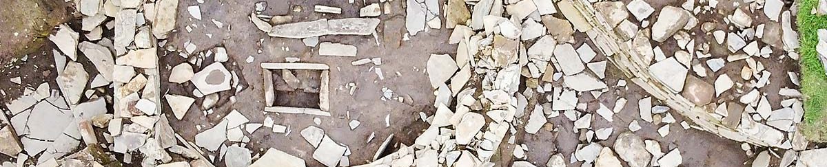
The re-excavation allowed the archaeologists to view what Petrie had presumably witnessed in 1857/58. Seeing the cist first-hand, the parallels between its architecture and that of the Early Neolithic were striking – if not slightly puzzling at first.


Measuring 1.45 metres long by 0.64 metres wide, the cist was unusually large. [5]
The two substantial orthostats at the centre of the long sides, and at right angles to them, were very reminiscent of the uprights that divided the interiors of Orkney-Cromarty stalled cairns and Early Neolithic stone-built houses. These, however, pre-date the cist by at least 1,600 years.
Why was this form – one that had not been encountered in this context before – adopted for the Bronze Age cist?
Early Neolithic house

A possible explanation lay a short distance to the north-east, where, in 2002, the unexpected remains of an Early Neolithic house had been uncovered. Based on its architecture the house clearly dated from the fourth millennium BC. [5]
The building was constructed sometime between 3400BC and 3100BC. The different wall sections showed the house had seen at least three phases of occupation and alteration during its 200-year lifespan. [5]

Orientated NNE-SSW, the sub-rectangular structure was built on the edge of a slope with its southern end cut into it.
With an estimated internal area of nine metres by 4.5 metres, little remained of the first phase but the surviving masonry – inner and outer wall faces with a clay/rubble core – was typical of Orcadian Neolithic construction.
The building was slightly smaller than the Early Neolithic house at the Knap of Howar, in Papa Westray, but like it probably had entrances to the north and east. [5]
We now know it was also like the first phase of the much-larger Structure Five at the Ness of Brodgar, which was probably built around the same time.
Like its contemporaries across Orkney, the interior of the Knowes of Trotty house was sub-divided by upright orthostats. Charcoal from a shallow, scoop-cut hearth in the southern half provided a radiocarbon date of 3350-3080BC. [5]
In the northern half, a shallow, oval pit had been lined with flagstones and contained a midden deposit incorporating pottery sherds from seven different vessels, burnt bone and birch charcoal. This charcoal was radiocarbon dated to 3500-3460BC.
The function of the pit is unclear – it was too wide and shallow to have been a post-hole and despite the charcoal in the midden fill, there was no evidence of burning meaning it had not served as a fire-pit. [5]
This is interesting as it shows the midden in the pit must have been brought into the building before the pit was paved over, indicating other, possibly earlier, occupation in the vicinity.
Like the double-structures at the Knap of Howar, it may be that the Knowes of Trotty house had a second, adjoining building, accessed from the eastern entrance. If so, this structure sat slightly higher and at the end of its life was demolished and the area used as an external yard/work area. [5]
Phase two

In its second phase the house was rebuilt on a slightly smaller scale. Although the shape of the interior was similar it was shorter (6.8 metres north-south) and narrower (3.6 metres east-west) than its predecessor.
The northern doorway was blocked and the eastern entrance extended and lined with stone slabs.
At the same time a rectangular, stone fireplace was inserted into the floor of the southern half, slightly north of the earlier scoop hearth and perhaps replacing another fire-pit. [5]
The north end of the new hearth was precisely aligned to the central line of the house, which itself was marked by the orthostatic dividers that separated the building into two rooms.
The northern and southern sections were further defined by a difference in height, the southern end being 40 centimetres lower. [5]
This slope, suggested the excavators, created a “subliminal psychological effect” with people having to walk down to the hearth and into the “semi-subterranean rear of the house and up towards the exits and the outside world”. [5]
It also confirms the building must have been well drained and watertight – lighting and maintaining a fire in a wet environment would have been problematic.
The notion that the descent into the southern half had some deeper significance seems borne out by alterations made to its rear. A new wall inserted across the southern end created a separate chamber at the rear of the building.
Access was by an entrance at the western end and a post-hole by the doorway suggests the new chamber could be closed off by a door or hanging. [5]
It has long been proposed that there was a special significance attached to the rear – the innermost area – of later Neolithic houses. This was marked by the construction of the so-called “dressers”, the best surviving examples of which can be seen at Skara Brae.
It may be that the rear chamber at the Knowes of Trotty house was a precursor to this – a sacred, or special, area that “endured, developing into the ‘dressers’ or house altars…” [5]

Something similar can perhaps be seen in contemporary funerary monuments. Inside the stalled Orkney-Cromarty cairns the end chambers were usually marked by a single massive stone slab.
Reaching the end compartment, at the rear of the structure, required movement along the length of the chamber and between a series of paired orthostats projecting from the walls.
Progress through the chamber was halted at the end compartment – the way blocked by the imposing backslab.
Colin Richards had no doubt these gigantic slabs were the end goal for those passing through the “doorways” formed by the rows of orthostatic pairs. [6]
What did they represent? To Richards it was “the doorway to immortality and another world, the door to which is always closed to humanity.” [6]
However it was used, and whatever it represented, the rear chamber in the Knowes of Trotty house seems to have been short-lived and was filled with masonry from one of more collapses of the original southern wall. [5]
Outside the building a small annex, with a south-facing doorway, was added to the exterior of the eastern entrance. Measuring just 2m by 1.4m, the new addition was paved, with floor deposits suggesting household waste was either dropped or placed within.
A work area outside showed evidence of flintworking and pottery – including a possible kiln. [5]
Although the house was subject to episodes of repair and alteration throughout this period, life seems to have continued more or less the same.
One notable change related to the fuel used within the fires. In the stone hearth the residue was almost entirely burnt peat but later in the building’s life turf may have become a major source of fuel. That said, the presence of charcoal (birch) in most phase two samples suggests that wood was probably the main fuel source. [5]
During this phase an arc of stone blocks was placed in the building’s north-western corner. This may either have related to a curved screen or partition or was perhaps the remnants of radial divisions akin to the cells found at the Knap of Howar. [5]
Phase three

At some point the house either collapsed or was partially demolished.
The resulting rubble and midden were pushed into the interior after hearth had been carefully covered over with stones, decommissioning and sealing it.
It seems the focus of occupation had shifted. A substantial drain constructed on the ruins suggests a new building now stood to the north-east.
The fragmentary nature of the remains, however, made it difficult to discern the number of buildings nor their form. It has been suggested that phase three activity was either more transient or that smaller buildings or shelters clustered around open air work areas. [5]
The final activity on the site of the original house was the construction of a small stone box cut into a later hearth that had been placed against a wall section.
Filled with clay and stones, the function of this box is unknown but its inclusion has parallels with Structure One at Stonehall Farm, Firth, where a hearth was replaced by a stone cist. [7]
Neolithic settlement

Looking at Neolithic settlement patterns throughout Orkney it seems unlikely that the Knowes of Trotty house stood alone. Although we do not yet have conclusive proof it was part of a larger “village”, there are indications that it might have been.
Around 170 metres to the east of the structure geophysics revealed an anomaly measuring 30 metres in diameter. Although no walling was detected, sample analysis suggested it represented “redeposited domestic debris relating to Neolithic settlement”. [5]
A second anomaly, 150 metres south of the house, had a diameter of 14 metres. Subsequent excavation revealed a badly damaged, 1.5-metre-wide wall that, given its form, was probably Neolithic. [5]
So, with “tantalising glimpses” of further settlement to the south and east of the Knowes of Trotty house, were there more?

Here we return to the Bronze Age barrow on Mound One.
A few years previously, excavation at the Stonehall settlement had encountered a series of Neolithic buildings constructed on top of a natural knoll. This elevated position had brought structural problems but, despite these, the inhabitants persevered. Clearly it had been desirable to remain on that site, the benefits presumably far outweighing the negatives. [8]
As we saw above, the Bronze Age barrow at the Knowes of Trotty had been raised on top of a natural, glacial drumlin. Excavation suggested, however, that earlier buildings had occupied the summit of the mound – structures that had been levelled to allow the barrow’s construction. [5]

If the barrow was preceded by one or more Neolithic structures, was it influenced by their architecture? This would certainly explain some of the features encountered in its construction.
The cist, for example, was very similar in size and form to the stone hearth in the nearby Phase Two Neolithic house. [5]
The cist’s flanking orthostats, the excavators proposed, represented the orthostatic dividers in Early Neolithic houses (and, by extension, stalled cairns). Taken together, the architecture of the cist and its flanking orthostats was “deliberately drawing upon the dominant features [of the] early Neolithic houses.” [5]
Another unusual element was the inclusion of midden material and large, flat slabs in the body of the barrow mound.
This “almost certainly comprises rubble and debris from the Neolithic house, either from a house upon this glacial mound, or from the one that was excavated, or both.” [5]
The appropriation of Neolithic sites in later prehistory is not uncommon. The Ness of Brodgar, particularly the area surrounding the Ring of Brodgar, remained a focus for both Bronze Age domestic and funerary activity.

The Bookan chambered cairn, to the north-west of the stone circle, and the Tresness cairn, in Sanday, are two examples of Neolithic mortuary structures altered in the Bronze Age and re-used for the deposition of human remains. But excavation has also shown that Bronze Age re-use was not restricted to funerary monuments but also targeted occupation sites.
Why?
Probably the same reason Iron Age people gravitated towards earlier sites – they represented a link to the past and, in some cases, were perhaps attempts to legitimise claims to land and/or secure social status.
The Neolithic sites were already ancient in the Bronze Age and probably tightly woven into a tapestry of myth and legend blanketing the landscape.
At the Knowes of Trotty, the decision to erect a barrow cemetery on the site of a possible Neolithic settlement – not to mention placing the primary burial directly on top of the remains of a structure – was a statement.
To the excavators, it was “almost certainly a desire … to draw power and authority to themselves and their emergent ancestors by emphasising origins, situating their burial monuments upon the remains of their ‘founding-fathers’”. [5]
These sites, wrote Professor Mark Edmonds, “were no longer historic; they were a part of the mythic landscape” and, as such, probably chosen as “burial grounds for lineages who were still looking to the past.” [1]

Notes
- [*] The name means “mounds of the trow-marsh”, with trows being supernatural, mound-dwelling creatures in Orcadian folklore.
- [1] Edmonds, M. (2019) Orcadia: Land, Sea and Stone in Neolithic Orkney. Head of Zeus Ltd.
- [2] Petrie, G., 1862. Notice of a barrow at Huntiscarth in the parish of Harray, Orkney, recently opened. In Proceedings of the Society of Antiquaries of Scotland (Vol. 3, pp. 195-195).
- [3] Sheridan, A. https://www.nms.ac.uk/collections-research/our-research/featured-projects/prehistoric-gold/gold-object-of-the-week/gold-object-of-the-week-3/
- [4] https://canmore.org.uk/c14index/2035
- [5] Downes, J., Sharman, P., Challands, A., Guttman-Bond, E., McKenzie, J., Towers, R. and Voke, P.D. (2016). Place in the Past: an early Neolithic house at the Knowes of Trotty barrow cemetery, Harray, Mainland, Orkney. In Richards, C. and Jones R. (eds) The Development of Neolithic House Societies in Orkney. pp.41-63. Oxbow: Oxford.
- [6] Richards, C. (1993) An archaeological study of Neolithic Orkney: architecture, order and social classification.
- [7] Richards, C., Jones, R., Challands, A., Jeffrey, S., Jones, A., Jones, S. and Muir, T. (2016) At Stonehall Farm, late Neolithic life is rubbish. In Richards, C. and Jones R. (eds) The Development of Neolithic House Societies in Orkney. pp.41-63. Oxbow: Oxford.
- [8] Richards, C., Brophy, K., Carruthers, M., Jones, A.M., Jones, R. and Jones, S. (2016) Good Neighbours: Stonehall Knoll, Stonehall Meadow and Stonehall Farm. In Richards, C. and Jones R. (eds) The Development of Neolithic House Societies in Orkney. pp.41-63. Oxbow: Oxford.


