


Until the early years of the 21st century, a massive whaleback mound at the south-eastern end of the Ness of Brodgar was believed to be a natural feature.
Aside from the two standing stones in the garden of Lochview there was little to see.
For centuries, countless thousands had passed the giant mound while travelling between the Ring of Brodgar and Stones of Stenness. But, despite some clues, few gave it a second glance.
In 2002, a project to geophysically survey the entire Orkney World Heritage Site began.
Shortly afterwards, it reached the southern tip of the Ness, where the results revealed a dense cluster of sub-soil anomalies. Indicative of settlement, these geophysical anomalies covered an area of 2.5 hectares and their sheer concentration, and variation, astonished archaeologists.
A few months later, in March 2003, a large, notched stone was ploughed up in the area.

Initially, it was believed this stone was part of a Bronze Age burial cist. And because that meant human remains may have been disturbed, a rescue excavation was launched, with Beverley Ballin Smith and Gert Petersen, from the Glasgow University Research Division, carrying out the work.
There was no cist but what was revealed was part of a large Neolithic building, very similar to House Two at the nearby Barnhouse settlement.
That building was what we now refer to as Structure One.
Following its discovery, a resistivity survey was carried out to define the extent of the built archaeology and to complement the previous gradiometer scans.
The results confirmed that something large, and very complex, lay under the soil.
So further investigations began.
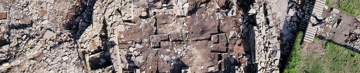
To examine the nature, depth and extent of the suspected archaeological deposits, eight test-trenches were placed across the site in 2004. These confirmed, without a doubt, that much of the mounded ridge was artificial and covered a huge complex of structures and middens, all dating from the Neolithic.


2004: Ness of Brodgar test pits. (📷 Sigurd Towrie)
Excavation ran until August 2024, when the project focus shifted to the post-excavation analysis of the data collected over the past two decades.


