
Evolution of an excavation – the Ness dig year by year
At the time of writing, it is just over 17 years since the discovery of the Ness of Brodgar complex and 2020 will be the first time since 2003 that no excavation will take place on site.
So while work continues to raise the funds needed to get back to the Ness in 2021, we thought readers might like to see how the dig has progressed (and ideas changed) over the years via dig director Nick Card’s annual brief summaries for Archaeology Scotland’s Discovery and Excavation in Scotland. Annotations, in red, put the archive information into current site context.
We’ll begin today with 2003-2006 and continue in a series of posts over the next few weeks.

2003

(By Beverly Ballin-Smith, GUARD, who carried out the initial evaluation)
(Click here to download excavation data structure report)
A large, unusually notched and rebated stone was found during ploughing.
A geophysical survey undertaken in 2002 had indicated considerable archaeological activity, especially in the southern portion of the field.
Circular, rectangular and linear features were recorded which form part of a settlement complex continuing south into the adjoining property of Lochview. Also of importance is the generally increased magnetic response of the majority of the field.
The opening of a 34.5m² trench in April 2003 revealed the presence of an arc of stones set on edge outlining part of a structure.
Within the arc were the remains of a double-faced coursed wall forming two rectangular recesses or arms of a cruciform interior space. The building has been identified as a Late Neolithic building [Structure One] similar in form to others excavated at Barnhouse, barely 0.5km to the south-east.

The trench exposed midden deposits which also lay between and around the building. These deposits were traced as a continuous feature in the southern extension of the trench.
At its southern end, the midden was interrupted by stones forming part of another structure. These stones were similar to the notched stone and it is likely that this stone originated from this stonework or from the structure it represents.
The site is well placed on high ground between the lochs of Stenness and Harray, close to the monuments of the Stones of Stenness and the Ring of Brodgar, and lies within the Inner Buffer Zone to the World Heritage Site of The Heart of Neolithic Orkney.
Following exploratory excavation in April 2003, a resistivity survey in October 2003 both clarified the extent and nature of the anomalies shown by the previous magnetometry survey and also defined several new structures and features.
2004


In light of discoveries on the Ness of Brodgar in recent years of a large prehistoric complex, further evaluation and assessment of the site was undertaken in June 2004.
Eight trial trenches were opened, showing that the dense concentration of features revealed by the geophysical surveys was only the ‘tip of the iceberg’.
Although the trenches were deliberately located away from significant geophysical anomalies, in only one trench was it possible to reach natural without structural archaeology being encountered.
The preliminary results appear to indicate that much of this substantial mound is artificial, comprising structures, middens and deep midden-enhanced soils dating to the Neolithic. In one trench part of a previously unrecorded chambered cairn was revealed.

A substantial double linear feature revealed by resistivity, and thought prior to excavation to be probably medieval, now appears to be prehistoric and probably relates to other Neolithic activity on the site.
Soil samples were also obtained for research looking at wider issues, such as early land management, palaeoenvironments and other significant information relevant to the interpretation of the World Heritage Site.
2005
In light of the recent discovery on the Ness of Brodgar of a large prehistoric complex, further evaluation and assessment of the site was undertaken in June 2005.
The emphasis this season was to determine the nature and date of a large double linear anomaly revealed by resistivity survey and initially investigated by trial trenching in 2004. The unity of this feature, as suggested by the initial resistivity survey, was revealed as being the product of a number of chronologically separate features. This was confirmed by refined geophysical survey this year.

Two main trenches were opened, one on the external ‘corner’ of this feature (Trench J); the other over a central portion of the anomaly (Trench I).
The ‘corner’ of a large structure was uncovered in the former trench. This was defined by a massive wall of natural boulders, c 3m wide, faced on one side and covered by cairn material [Northern Boundary Wall aka ‘Great Wall of Brodgar’]. Within the cairn material a polished stone axe was recovered. Refined geophysical survey around this structure suggests it is part of an oval anomaly c.15m in diameter.
In the larger trench a sequence of badly plough-truncated structures was uncovered.
These included a “stalled” structure; a large rectangular structure, represented by two parallel wall lines defining a structure, at least 5m long by 3m; and a further two anomalous structures centred on large square stone hearths. Most of the structures exhibit elements found in the repertoire of known Neolithic structures.
Further soil samples were obtained for part of a PhD thesis looking at wider issues such as early land management, palaeoenvironments and other significant information relevant to the interpretation of the World Heritage Site.
2006

In light of the recent discovery on the Ness of Brodgar of a large prehistoric complex, further investigation of the site was undertaken in 2006.
Fieldwork consisted of two separate phases. The first in February 2006 was to investigate the reported slumping on the top of the mound [location of Trench T]. The excavation revealed that a large dump of both modern and redeposited Neolithic material on the top of the mound was gradually settling.

This dump was the result of the field being ‘squared’ off in the mid 1880s. Neolithic finds recovered included decorated Grooved Ware (both incised and applied decoration) and a piece of Arran pitchstone. The results support the theory that this site forms part of the Neolithic complex on the Ness and is probably the remnants of a large chambered cairn, or a stepped cairn or platform bounded by concentric revetments as at Bookan.
The second phase, in August, concentrated on the large structure partially revealed in 2005 (Trench J).
This showed that the substantial wall previously uncovered was an outer element of a far larger structure than previously envisaged [‘Great Wall’]. Within this outer wall, and concentric to it, was an oval structure c 8m by 6m with radial divisions and a short entrance passage to the south-east [Structure Five].
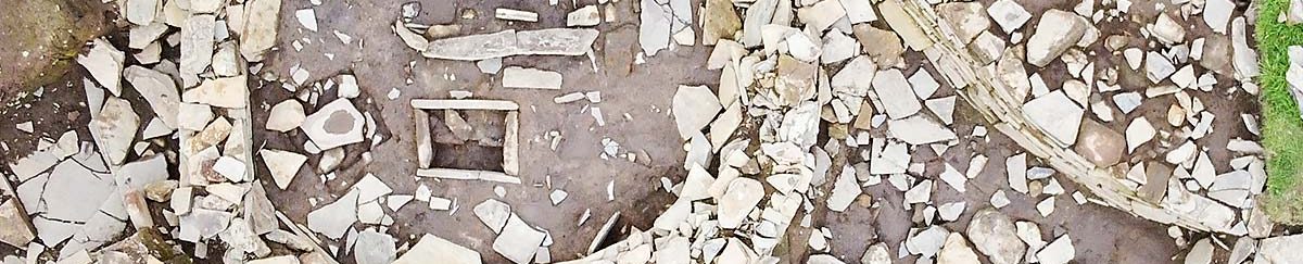
Although the primary levels were not reached several phases of collapse and use were identified. A late phase of use was associated with a hearth and the insertion of a large ‘drain’.
Ephemeral wall lines, a rectangular stone setting, hearths, peat-ashy spreads, a flint cache and a triangular ‘cist’ indicated later activity on the top of these structures. Two conjoining thin stone slabs from the top of the cist exhibited incised Neolithic motifs.


